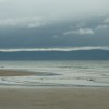
Sand dunes near Castlerock

Uploader's Comments
There is a long stretch of dunes between Castlerock golf course, the railway and the Bann. They end close to the Barmouth [[213407]]. The sand (foreground) will be covered at high water. The Google map lacks accuracy here.
Uploaded to Geograph by Albert Bridge on 12 June 2010