Approximate Location Map
Use two fingers to pan or zoom the map
Use two fingers to pan or zoom the map
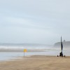
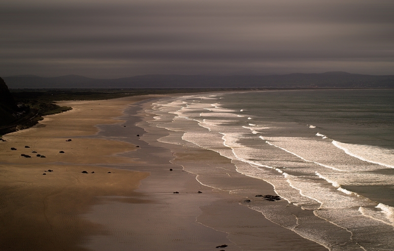
The Magilligan Benone Strand Beach, also known as Downhill Strand, is a 7-mile stretch of sand and surf that runs from just west of Castlerock to Magilligan Point. The beach is particularly popular with coastal ramblers and offers a range of marine and land-based outdoor recreation activities.
The beach features a supervised playground, outdoor paddling pool, and golf club. It is also home to one of the largest sand dune systems in the UK and Ireland, which is part of the Binevenagh Area of Outstanding Natural Beauty (AONB), an Area of Special Scientific Interest (ASSI), and part of the Magilligan Special Area of Conservation (SAC). The beach has won the prestigious Blue Flag Award multiple times and offers safe swimming with lifeguards on duty from June to early September.
The beach and its surrounding area have been designated as an Area of Special Scientific Interest (ASSI) and a Special Area of Conservation (SAC) due to its unique natural features. The sand dunes and cliffs provide a habitat for a variety of flora and fauna, making it a nature lover's paradise.
The beach is accessible with free car parking on the beach front, as well as disabled toilets and disabled parking. Dogs are allowed on Benone Beach, with restrictions from June 1st to September 15th. The beach also has zoned areas for watersports, including surfing, jetskis, and kayaking.
The beach was recently used as a location for Dragonstone in the Game of Thrones, where the Seven Idols of Westeros were burned. The iconic Mussenden Temple, located on the cliffs overlooking the Atlantic Ocean, is a popular tourist attraction.
Sand
| Today | |
|---|---|
| Chance of rain | 100% |
| Max temperature | 14°C |
| feels like | 14°C |
| Wind 21mph | |
| Max UV Index |
| Tonight | |
|---|---|
| Chance of rain | 98% |
| Min temperature | 9°C |
| feels like | 10°C |
| Wind 22mph |
The tide at Magilligan Benone Strand Beach is currently falling. Low tide will be at approximately 3:49 PM, and the next high tide will be at approximately 10:22 PM.
![]() Today's air pollution levels are forecast to be Low
Today's air pollution levels are forecast to be Low
Limited parking available at beach entrance. Free managed parking on beach during peak season.
Dogs not allowed on certain areas May to September.
Beach manually and mechanically cleaned daily during the summer and weekly the rest of the year
Daily - 18th June - 4th September
Weekends - 30th April - 12th June; 10th - 25th September
Easter Bank Holiday - 25th - 28th March
![]()
![]()
Beachside and Golf Apartment

From £1725.00 per week at Sykes Holiday Cottages
Tranquility

From £5000.00 per week at Sykes Holiday Cottages
Quiet Waters Cottage

From £2688.00 per week at Sykes Holiday Cottages
Seaview

From £2018.00 per week at Sykes Holiday Cottages
Rosies Cottage

From £1946.00 per week at Sykes Holiday Cottages
Church Studio

From £1002.00 per week at Sykes Holiday Cottages
Mussenden Temple (2.5 miles)
Red Duck Diving (3.3 miles)
Downhill Demesne & Hezlett House (3.4 miles)
Scenic Lough Foyle Ferry (5 miles)
All distances are approximate
around 2 miles east as the seagull flies, around 3 miles by road.
around 3 miles east as the seagull flies, around 5 miles by road.
around 5 miles east as the seagull flies, around 14 miles by road.
around 9 miles east-northeast as the seagull flies, around 15 miles by road.
around 9 miles east-northeast as the seagull flies, around 16 miles by road.
around 11 miles east-northeast as the seagull flies, around 18 miles by road.
around 13 miles east-northeast as the seagull flies, around 20 miles by road.
around 25 miles east as the seagull flies, around 31 miles by road.
Coordinates: 55°10'5"N 6°52'24"W
Mapcode: IRL PF.80S9
What 3 Words: inserting.girder.conned
Coordinates and location codes are for an approximate mid-point of the beach, and may not reflect the best access point or the most popular part of the beach.
County: Londonderry
Country: Northern Ireland
Local Authority: Limavady
Nearest postcode: BT49 0LQ
(for sat-nav purposes only, a beach does not have a postal address!)
Important! Beach information is compiled from a variety of different sources and is correct to the best of our knowledge at the time of compilation. However, information may be incorrectly supplied by our sources or go out of date after publication. BritishBeaches.uk makes no warranty as to the accuracy of any information on this page.
(Or après-beach. Or pre-beach. Or, just because you might want stuff)
Men's Tops
Weird Fish Fished Branded T-Shirt Smoked Blue Size 5XL

Only £25.00 from Weird Fish