Approximate Location Map
Use two fingers to pan or zoom the map
Use two fingers to pan or zoom the map
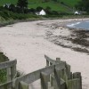
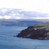
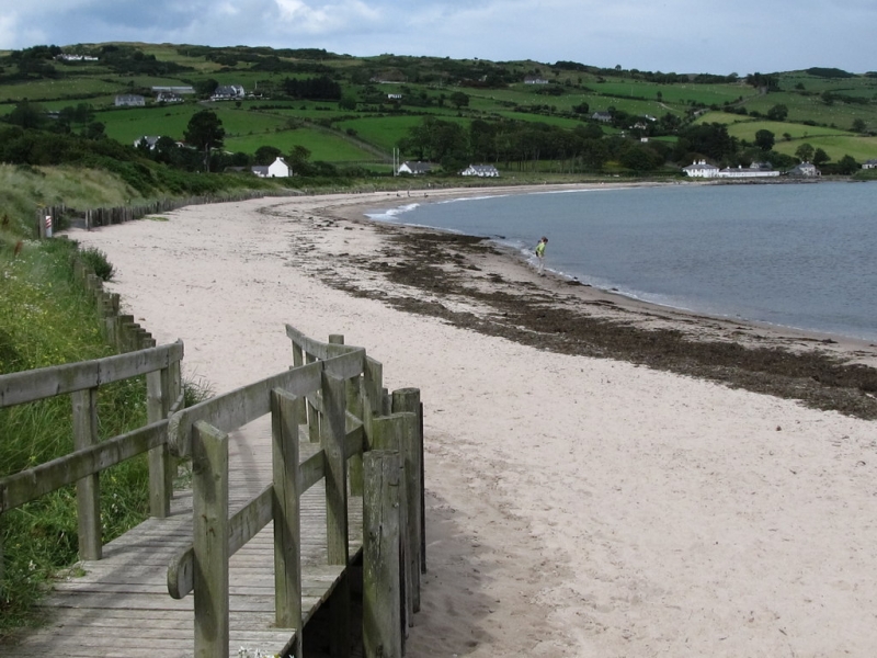
Cushendun Beach is a wide sandy bay backed by the picturesque village of Cushendun, which is mostly owned by the National Trust. The village is situated at the mouth of the River Dun, also known as the Brown River, and at the foot of Glendun, one of the renowned Glens of Antrim.
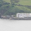
The village of Cushendun is a charming rural settlement with many picturesque buildings, some of which have a distinctly Cornish feel to them. These buildings were designed in this style to please the wife of a local landowner, who came from Penzance. The village offers a range of amenities, including a pub, which was once the smallest pub in Ireland, a chip shop, and a National Trust-run tearoom.
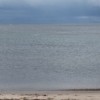
The beach itself is a gently curving bay with a wide sandy shoreline. On clear days, there are views across to the Mull of Kintyre, which is approximately 15 miles away. The Glendun River enters the sea in the village, at the southern end of the bay, where there is a small, sheltered harbour and a car park. A further car park can be found a short drive along the coast road, heading north out of the village.
The countryside around the bay offers plenty of walking trails and features beautiful Glendun. The ruins of Carra Castle lie a short distance behind the bay, and there are a number of Bronze-Age standing stones in the area. Game of Thrones fans may be interested to visit Cushendun's Red Caves, where some scenes from the hit TV series were filmed.
Sand
| Today | |
|---|---|
| Chance of rain | 99% |
| Max temperature | 14°C |
| feels like | 13°C |
| Wind 20mph | |
| Max UV Index |
| Tonight | |
|---|---|
| Chance of rain | 96% |
| Min temperature | 9°C |
| feels like | 10°C |
| Wind 21mph |
The tide at Cushendun Beach is currently rising. High tide will be at approximately 2:40 PM, and the next low tide will be at approximately 8:05 PM.
![]() Today's air pollution levels are forecast to be Low
Today's air pollution levels are forecast to be Low
Two national trust car parks.
No lifeguard cover at this beach
Woodleigh Cottage

From £1997.00 per week at Sykes Holiday Cottages
Rosies Cottage

From £1946.00 per week at Sykes Holiday Cottages
Hill House

From £1923.00 per week at Sykes Holiday Cottages
Alken Caravan

From £1422.00 per week at Sykes Holiday Cottages
Alken Cabin

From £1657.00 per week at Sykes Holiday Cottages
Carriguisnagh

From £2579.00 per week at Sykes Holiday Cottages
Cushendun Village (0.1 miles)
Game of Thrones Tour (0.3 miles)
Caves of Cushendun (0.3 miles)
Johnny Joes (McCollums) (3.4 miles)
All distances are approximate
around 3 miles south as the seagull flies, around 5 miles by road.
around 9 miles northwest as the seagull flies, around 11 miles by road.
around 10 miles south-southeast as the seagull flies, around 15 miles by road.
around 10 miles south-southeast as the seagull flies, around 16 miles by road.
around 11 miles south-southeast as the seagull flies, around 18 miles by road.
around 17 miles south-southeast as the seagull flies, around 25 miles by road.
around 21 miles west-northwest as the seagull flies, around 25 miles by road.
around 22 miles south-southeast as the seagull flies, around 43 miles by road.
around 23 miles west-northwest as the seagull flies, around 28 miles by road.
around 25 miles west-northwest as the seagull flies, around 29 miles by road.
around 25 miles west-northwest as the seagull flies, around 30 miles by road.
around 28 miles west as the seagull flies, around 36 miles by road.
around 30 miles west as the seagull flies, around 38 miles by road.
around 31 miles west as the seagull flies, around 38 miles by road.
Location: Cushendun
Coordinates: 55°7'38"N 6°2'31"W
Mapcode: IRL VD.GL63
What 3 Words: laying.bubble.dragonfly
Coordinates and location codes are for an approximate mid-point of the beach, and may not reflect the best access point or the most popular part of the beach.
County: Antrim
Country: Northern Ireland
Local Authority: Moyle
Nearest postcode: BT44 0PJ
(for sat-nav purposes only, a beach does not have a postal address!)
Important! Beach information is compiled from a variety of different sources and is correct to the best of our knowledge at the time of compilation. However, information may be incorrectly supplied by our sources or go out of date after publication. BritishBeaches.uk makes no warranty as to the accuracy of any information on this page.
(Or après-beach. Or pre-beach. Or, just because you might want stuff)
Men's Tops
Weird Fish Barkson's Farm Back Print Artist T-Shirt Smoked Blue Size 4XL

Only £28.00 from Weird Fish