Approximate Location Map
Use two fingers to pan or zoom the map
Use two fingers to pan or zoom the map
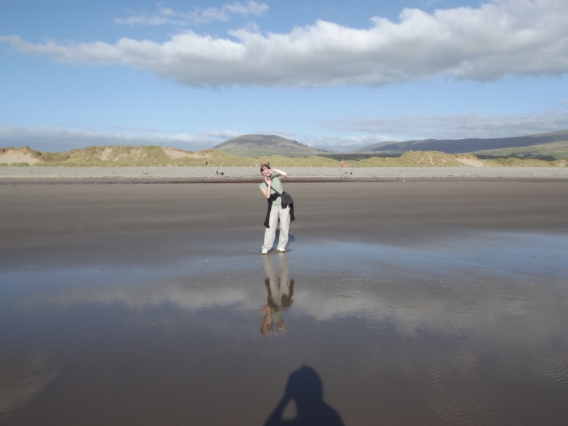
Dyffryn Beach is situated on the coastline of Cardigan Bay, between Barmouth and Harlech. The beach is relatively flat, made up of sand and pebbles, stretching for 8 kilometres to the north of Barmouth. A number of caravan sites are located to the south of the beach. The dune system behind the beach is part of the Morfa Dyffryn Site of Special Scientific Interest and the Morfa Dyffryn National Nature Reserve, reflecting the environmental importance of the site.
The dune system is a National Nature Reserve and a permit should be obtained from the Countryside Council for Wales before visiting them. The beach and dune system are also part of the Morfa Harlech a Morfa Dyffryn Special Area of Conservation. The Morfa Dyffryn National Nature Reserve is one of the most important dune systems in Wales due to its bare sand and wildlife habitats.
The beach is well known for its fine sand dunes and is a popular spot for families and holidaymakers. The central part of the beach stretches for miles, with sand dunes rising behind the beach and vast expanses of scrubland. The sands of Morfa Dyffryn are clean and soft, extending into the sea at a gentle slope, making it a safe spot for swimming. Views of Snowdonia, the Rhinog Mountains, Tremadog Bay, and the Llyn Peninsula can be seen from the beach.
Dyffryn Beach is also an officially recognised naturist beach, with a designated naturist area stretching for around a mile. The naturist area is separate from the main beach and has been used as a naturist spot since the 1920s. Clear signage has been added to mark the area, and it is usually used by a mixture of visitors, including families.
A new boardwalk stretches from the Snowdonia National Car Park through the dunes, offering disabled access to the beach. However, it is a long walk, mostly flat. There are no facilities on the beachfront, but a general store is located at the Dyffryn Seaside Estate holiday park.
Llanendwyn Beach is adjacent to the Wales Coast Path.
Sand
| Today |  |
|---|---|
| Chance of rain | 74% |
| Max temperature | 17°C |
| feels like | 19°C |
| Wind 21mph |  |
| Max UV Index |  |
| Tonight |  |
|---|---|
| Chance of rain | 14% |
| Min temperature | 13°C |
| feels like | 18°C |
| Wind 16mph |  |
The tide at Llanendwyn Beach is currently rising. High tide will be at approximately 2:11 PM, and the next low tide will be at approximately 9:14 PM.
 Today's air pollution levels are forecast to be Low
 Campsite
There is a public car park right next to the beach.
Restrictions apply.
No lifeguard cover at this beach


Excellent water quality
just over a mile southeast as the seagull flies, around 3 miles by road.
around 3 miles north as the seagull flies, around 6 miles by road.
around 5 miles south-southeast as the seagull flies, around 6 miles by road.
around 5 miles north as the seagull flies, around 7 miles by road.
around 7 miles south-southeast as the seagull flies, around 20 miles by road or 9 miles on foot using coastal paths.
around 8 miles south as the seagull flies, around 22 miles by road or 13 miles on foot using coastal paths.
around 9 miles north-northwest as the seagull flies, around 20 miles by road.
around 9 miles north as the seagull flies, around 17 miles by road.
around 10 miles north-northwest as the seagull flies, around 19 miles by road.
around 10 miles north-northwest as the seagull flies, around 20 miles by road.
around 10 miles north-northwest as the seagull flies, around 21 miles by road.
around 12 miles northwest as the seagull flies, around 25 miles by road.
around 13 miles northwest as the seagull flies, around 27 miles by road.
around 14 miles south as the seagull flies, around 31 miles by road or 20 miles on foot using coastal paths.
around 14 miles west-northwest as the seagull flies, around 30 miles by road.
around 16 miles west-northwest as the seagull flies, around 33 miles by road.
around 16 miles west as the seagull flies, around 37 miles by road.
around 16 miles west as the seagull flies, around 36 miles by road.
around 17 miles south as the seagull flies, around 34 miles by road or 26 miles on foot using coastal paths.
around 18 miles south as the seagull flies, around 45 miles by road or 36 miles on foot using coastal paths.
Location: Llanenddwyn
Location type: Village
OS Grid: SH568227
Coordinates: 52°47'0"N 4°7'27"W
Mapcode: GBR 5Q.XLMC
What 3 Words: channel.whoever.spurted
Coordinates and location codes are for an approximate mid-point of the beach, and may not reflect the best access point or the most popular part of the beach.
Country: Wales
Local Authority: Gwynedd
Parish: Dyffryn Ardudwy
Nearest postcode: LL44 2HD
(for sat-nav purposes only, a beach does not have a postal address!)
Important! Beach information is compiled from a variety of different sources and is correct to the best of our knowledge at the time of compilation. However, information may be incorrectly supplied by our sources or go out of date after publication. BritishBeaches.uk makes no warranty as to the accuracy of any information on this page.