Approximate Location Map
Use two fingers to pan or zoom the map
Use two fingers to pan or zoom the map
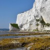
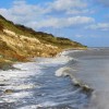
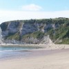
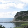
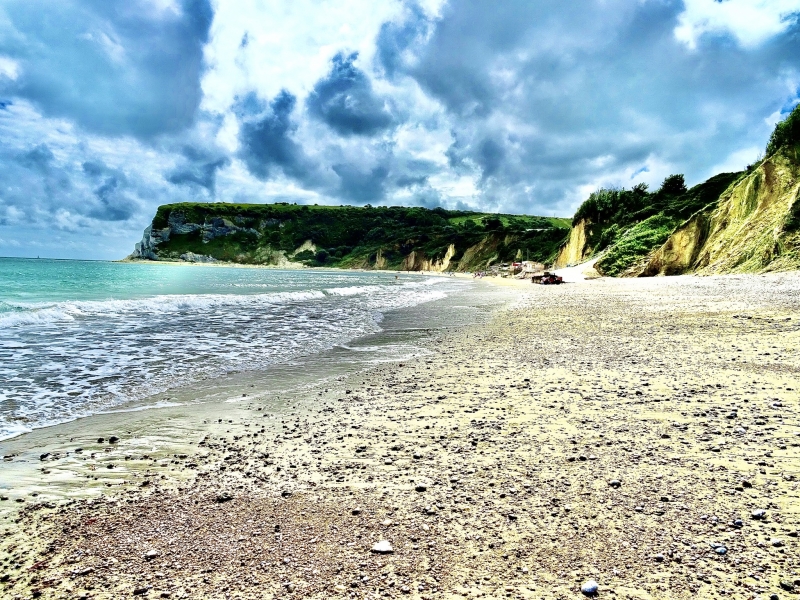
Whitecliff Bay is a pleasant privately owned sand and shingle beach, set in a bay and backed by Culver Cliffs and Whitecliff Bay Holiday Park. The beach is situated near the eastern tip of the Isle of Wight and is famous for its well-exposed sedimentary rock sequence, which yields an abundance of fossils. The mostly sandy beach slopes gently up to the base of the cliffs, with a rock ledge at the southern end.
The sand and shingle beach of Whitecliff Bay is approximately 200 metres long and is backed by two holiday parks, making it a popular spot during the summer. The beach is situated at the foot of the high chalk Culver Cliffs, which form part of a site of significant geological interest and are rich in fossils.
The beach has some facilities, including two cafes, but no toilets. Parking is limited, and access to the beach is via two steep concrete paths. The beach is privately owned by one of the holiday parks, but this does not affect public access.
Whitecliff Bay is adjacent to the Isle of Wight Coast Path.
Sand Shingle
| Today | |
|---|---|
| Chance of rain | 92% |
| Max temperature | 16°C |
| feels like | 16°C |
| Wind 27mph | |
| Max UV Index |
| Tonight | |
|---|---|
| Chance of rain | 51% |
| Min temperature | 12°C |
| feels like | 13°C |
| Wind 21mph |
The tide at Whitecliff Bay is currently falling. Low tide will be at approximately 7:48 AM, and the next high tide will be at approximately 2:57 PM.
![]() Today's air pollution levels are forecast to be Low
Today's air pollution levels are forecast to be Low
There is limited parking at the adjacent holiday park.
Dogs are allowed
Beach cleaned regularly.
No lifeguard cover at this beach
![]()
Excellent water quality
Swallows

From £2887.00 per week at Sykes Holiday Cottages
Starboard Light

From £2450.00 per week at Sykes Holiday Cottages
2A The Mews

From £2220.00 per week at Sykes Holiday Cottages
Luxury Isle Of Wight Cottage
From £494.00 per week at Holidaycottages.co.uk
Romantic Ashurst And Colbury House Cottage
From £677.00 per week at Holidaycottages.co.uk
The Studio

From £1221.00 per week at Sykes Holiday Cottages
Sally's Riding School (1 miles)
Bembridge Lifeboat Station (1.6 miles)
Adgestone Vineyard (2.8 miles)
Wight Karting (3.3 miles)
Goodleaf Tree Climbing (4.2 miles)
Isle of Wight Bus & Coach Museum (4.5 miles)
JURASSIC JIM (4.8 miles)
All distances are approximate
just over a mile northeast as the seagull flies, around 2 miles by road.
around 2 miles west-southwest as the seagull flies, around 3 miles by road.
around 3 miles west-southwest as the seagull flies, around 4 miles by road.
around 4 miles west-southwest as the seagull flies, around 5 miles by road.
around 5 miles southwest as the seagull flies, around 6 miles by road.
around 7 miles southwest as the seagull flies, around 10 miles by road.
around 10 miles northwest as the seagull flies, around 14 miles by road.
around 16 miles west as the seagull flies, around 21 miles by road.
around 18 miles west as the seagull flies, around 20 miles by road.
around 18 miles west as the seagull flies, around 21 miles by road.
around 20 miles west as the seagull flies, around 24 miles by road.
around 20 miles west as the seagull flies, around 24 miles by road.
around 2 miles north as the seagull flies, around 4 miles by road or 3 miles on foot using coastal paths.
around 3 miles north as the seagull flies, around 6 miles by road or 4 miles on foot using coastal paths.
around 4 miles north-northwest as the seagull flies, around 7 miles by road or 6 miles on foot using coastal paths.
around 5 miles north-northwest as the seagull flies, around 7 miles by road.
around 5 miles northwest as the seagull flies, around 7 miles by road.
around 7 miles north as the seagull flies, around 20 miles by road or 13 miles on foot using coastal paths.
around 7 miles north as the seagull flies, around 20 miles by road or 13 miles on foot using coastal paths.
around 8 miles north-northwest as the seagull flies, around 32 miles by road or 16 miles on foot using coastal paths.
Location: Hillway
Location type: Town
OS Grid: SZ641862
Coordinates: 50°40'20"N 1°5'38"W
Mapcode: GBR BFN.L7K
What 3 Words: farmland.condiment.watchdogs
Coordinates and location codes are for an approximate mid-point of the beach, and may not reflect the best access point or the most popular part of the beach.
Country: England
Local Authority: Isle of Wight
Parish: Bembridge
Nearest postcode: PO35 5PY
(for sat-nav purposes only, a beach does not have a postal address!)
Important! Beach information is compiled from a variety of different sources and is correct to the best of our knowledge at the time of compilation. However, information may be incorrectly supplied by our sources or go out of date after publication. BritishBeaches.uk makes no warranty as to the accuracy of any information on this page.
(Or après-beach. Or pre-beach. Or, just because you might want stuff)
Men's Tops
Weird Fish Amiens Mixed Stitch Cardigan Deep Teal Size 8

Only £30.00 from Weird Fish