Approximate Location Map
Use two fingers to pan or zoom the map
Use two fingers to pan or zoom the map
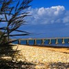
Bembridge Beach is made up of sand interspersed with rocky pools. At low tide, the Bembridge ledge is revealed, on which many ships have run aground over the years. The beach is surrounded by St Helens Duver, a Victorian golf course turned wildlife haven, managed by the National Trust, which is home to a variety of spectacular wildlife.
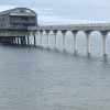
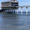
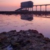
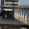
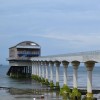
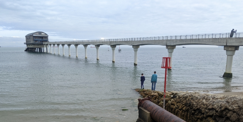
The beach is located beside the Lifeboat Pier and faces east towards Selsey Bill. At high tide, there can be little beach left, but at low tide, a good stretch of sand appears below the high water mark. A range of facilities are available nearby, including a cafe, car park, public toilets, and RNLI shop.
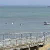
Bembridge Beach is popular for a range of water sports, including sailing, with a number of clubs located in the town of Bembridge. The beach is also a good spot for walking, with views of Portsmouth and the south coast of England. Visitors may also spot some of the big cross-channel ferries leaving from Portsmouth as they pass close to the coast here. During low tide, it may be possible to see Bembridge Ledge, a rocky outcrop that poses a particular risk to small, private boats.
There is pay-for parking, including disabled spaces, next to the lifeboat station along Fisherman’s Walk. There are also toilets, a shop, and a café here, as well as a pier that leads to the boathouse. The beach is accessed via a gentle slipway. Further parking can be found at the western end of the beach near the harbour, behind some sand dunes that lead down to the beach.
St Helen’s beach, located nearby, is a mixture of sand and pebbles with breakwaters, a sea wall, and promenade. The village of Bembridge offers a good range of facilities, including shops, pubs, and restaurants.
Bembridge Beach is adjacent to the Isle of Wight Coast Path.
Sand Rock
| Today | |
|---|---|
| Chance of rain | 89% |
| Max temperature | 16°C |
| feels like | 16°C |
| Wind 27mph | |
| Max UV Index |
| Tonight | |
|---|---|
| Chance of rain | 43% |
| Min temperature | 12°C |
| feels like | 13°C |
| Wind 22mph |
The tide at Bembridge Beach is currently falling. Low tide will be at approximately 7:48 AM, and the next high tide will be at approximately 2:57 PM.
![]() Today's air pollution levels are forecast to be Low
Today's air pollution levels are forecast to be Low
Parking available next to the beach.
Dogs are allowed.
No lifeguard cover at this beach
Good water quality
HW42

From £1677.00 per week at Sykes Holiday Cottages
Luxury Romantic Isle Of Wight Cottage
From £1459.00 per week at Holidaycottages.co.uk
Luxury Romantic Hampshire Cottage

From £715.00 per week at Holidaycottages.co.uk
Isle Of Wight Cottage
From £592.00 per week at Holidaycottages.co.uk
Luxury Isle Of Wight Cottage
From £428.00 per week at Holidaycottages.co.uk
Buddleia Cottage

From £1676.00 per week at Sykes Holiday Cottages
Bembridge Lifeboat Station (0.1 miles)
Sally's Riding School (0.5 miles)
Wight Karting (3.4 miles)
Adgestone Vineyard (3.9 miles)
Goodleaf Tree Climbing (4 miles)
Isle of Wight Bus & Coach Museum (4.5 miles)
Hovertravel (4.9 miles)
All distances are approximate
just over a mile southwest as the seagull flies, around 2 miles by road.
around 3 miles southwest as the seagull flies, around 4 miles by road.
around 4 miles southwest as the seagull flies, around 5 miles by road.
around 5 miles southwest as the seagull flies, around 6 miles by road.
around 6 miles southwest as the seagull flies, around 8 miles by road.
around 9 miles southwest as the seagull flies, around 11 miles by road.
around 18 miles west as the seagull flies, around 22 miles by road.
around 19 miles west as the seagull flies, around 22 miles by road.
around 19 miles west as the seagull flies, around 22 miles by road.
around 21 miles west as the seagull flies, around 25 miles by road.
around 21 miles west as the seagull flies, around 25 miles by road.
just over a mile west-northwest as the seagull flies, around 3 miles by road or 2 miles on foot using coastal paths.
around 2 miles northwest as the seagull flies, around 5 miles by road or 4 miles on foot using coastal paths.
around 3 miles northwest as the seagull flies, around 6 miles by road.
around 5 miles northwest as the seagull flies, around 7 miles by road.
around 5 miles northwest as the seagull flies, around 7 miles by road.
around 6 miles north as the seagull flies, around 21 miles by road or 12 miles on foot using coastal paths.
around 6 miles north as the seagull flies, around 21 miles by road or 12 miles on foot using coastal paths.
around 7 miles north as the seagull flies, around 22 miles by road or 14 miles on foot using coastal paths.
around 7 miles north-northwest as the seagull flies, around 20 miles by road or 11 miles on foot using coastal paths.
Location: Bembridge
Location type: Town
OS Grid: SZ657880
Coordinates: 50°41'17"N 1°4'15"W
Mapcode: GBR BFH.L23
What 3 Words: escalated.farms.embodied
Coordinates and location codes are for an approximate mid-point of the beach, and may not reflect the best access point or the most popular part of the beach.
Country: England
Local Authority: Isle of Wight
Parish: Bembridge
Nearest postcode: PO35 5TD
(for sat-nav purposes only, a beach does not have a postal address!)
Important! Beach information is compiled from a variety of different sources and is correct to the best of our knowledge at the time of compilation. However, information may be incorrectly supplied by our sources or go out of date after publication. BritishBeaches.uk makes no warranty as to the accuracy of any information on this page.
(Or après-beach. Or pre-beach. Or, just because you might want stuff)
Women's Outerwear
Weird Fish Langtree Lightweight Showerproof Padded Gilet Desert Sunset Size S

Only £48.75 from Weird Fish