Approximate Location Map
Use two fingers to pan or zoom the map
Use two fingers to pan or zoom the map
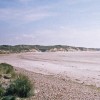
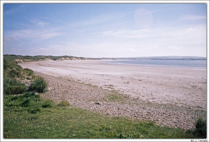
Dunnet Bay is a wide sandy bay located at the northern end of the sandy beach between Castletown and Dunnet, close to the north-eastern tip of Scotland. The pale expanse of sand stretches for over 2 miles and is backed by dunes and the grassy plains found along the north of Scotland, known locally as “machair”.
The closest facilities to this part of Dunnet Bay can be found in the village of Dunnet, which has a church, a small hotel, and the Seadrift-Dunnet Visitor Centre. The beach is a good spot for surfing, walking, or paddling in the waves.
Dunnet Head, which features the most northerly point of the United Kingdom mainland, lies just beyond the beach, above the mouth of the Dunnet Burn. This remote headland has a lighthouse, built in 1832, and provides plenty of opportunities for walkers and birdwatchers. The cliffs here provide nesting for a variety of seabirds. On a clear day, there are spectacular views from Dunnet Head along the coastline and out towards the Orkney Islands. Seals and the occasional dolphin may be spotted bobbing up and down in the surf.
Sand
| Today | |
|---|---|
| Chance of rain | 87% |
| Max temperature | 13°C |
| feels like | 13°C |
| Wind 11mph | |
| Max UV Index |
| Tonight | |
|---|---|
| Chance of rain | 90% |
| Min temperature | 10°C |
| feels like | 11°C |
| Wind 16mph |
The tide at Dunnet Beach is currently falling. Low tide will be at approximately 6:23 PM, and the next high tide will be at approximately 1:01 AM tomorrow.
![]() Today's air pollution levels are forecast to be Low
Today's air pollution levels are forecast to be Low
Parking available near the beach
No lifeguard cover at this beach
Excellent water quality
The Auld Kirk

From £2067.00 per week at Sykes Holiday Cottages
Rural Highland Council Farmhouse
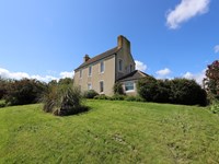
From £561.00 per week at Holidaycottages.co.uk
Dunnet Bay Distillery (0.4 miles)
Dunnet Head (2.7 miles)
The Castle and Gardens of Mey (4.9 miles)
All distances are approximate
just over a mile south-southwest as the seagull flies, around 2 miles by road.
around 6 miles west-southwest as the seagull flies, around 8 miles by road.
around 10 miles southeast as the seagull flies, around 21 miles by road or 15 miles on foot using coastal paths.
around 12 miles southeast as the seagull flies, around 16 miles by road.
around 16 miles west-southwest as the seagull flies, around 20 miles by road.
around 21 miles west as the seagull flies, around 26 miles by road.
around 24 miles west as the seagull flies, around 29 miles by road.
Location: Dunnet
Location type: Rural
OS Grid: ND217706
Coordinates: 58°37'0"N 3°20'53"W
Mapcode: GBR L53Y.M0M
What 3 Words: cyber.steps.spin
Coordinates and location codes are for an approximate mid-point of the beach, and may not reflect the best access point or the most popular part of the beach.
Country: Scotland
Local Authority: Highland
Nearest postcode: KW14 8XD
(for sat-nav purposes only, a beach does not have a postal address!)
Important! Beach information is compiled from a variety of different sources and is correct to the best of our knowledge at the time of compilation. However, information may be incorrectly supplied by our sources or go out of date after publication. BritishBeaches.uk makes no warranty as to the accuracy of any information on this page.
(Or après-beach. Or pre-beach. Or, just because you might want stuff)
Men's Tops
Weird Fish Shorling 1/4 Zip Striped Macaroni Sweatshirt Black Size S

Only £51.00 from Weird Fish