Approximate Location Map
Use two fingers to pan or zoom the map
Use two fingers to pan or zoom the map
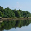
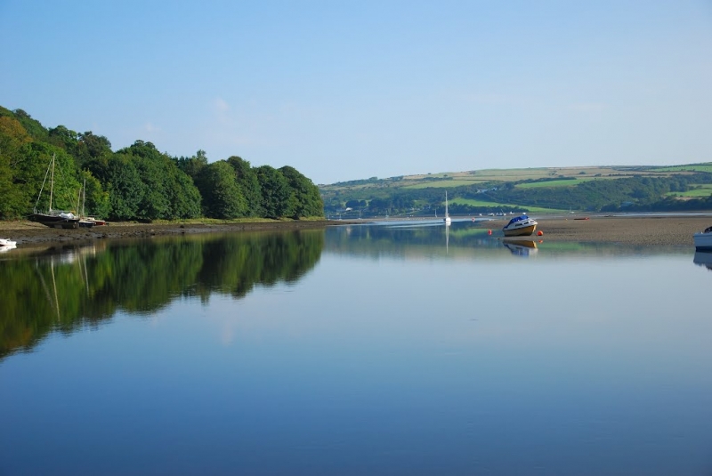
St. Dogmaels Slipway Beach is situated next to St Dogmaels village, on the banks of the River Teifi. The beach, which is a mix of sand and pebbles, looks out onto the river rather than the sea, but is a pleasant spot to stop for a picnic before setting out on one of the area's popular coastal walks. Swimming here is dangerous because of the presence of strong river currents. A number of small fishing boats are moored here, and seals, porpoises, and even bottle-nosed dolphins are frequently spotted along the nearby stretch of coast.
In contrast, Poppit Sands Beach, located on the southern bank of the River Teifi estuary, is a wide sandy beach with great views of Cardigan Island. The beach is backed by dunes full of wildlife and is a great base to explore the surrounding area. Poppit Beach is actually the start of the 186-mile long Pembrokeshire Coast Path, which also begins in St Dogmaels village. While swimming is possible at Poppit Sands, it is advised to exercise caution due to strong currents in the channel, although lifeguards are on duty here during the summer holidays.
Poppit Sands beach is popular for watersports, including windsurfing, kayaking, and surfing. Access to the beach is easy, with paid parking available right behind the Lifeboat station. St Dogmaels village, where the Pembrokeshire Coast Path starts, houses the remains of a 12th-century abbey, as well as having a pub, minimarket, and fish and chip shop.
St. Dogmaels Slipway Beach is adjacent to the Pembrokeshire Coast Path and the Wales Coast Path.
Bay Sand Pebbles
| Today | |
|---|---|
| Chance of rain | 100% |
| Max temperature | 15°C |
| feels like | 15°C |
| Wind 22mph | |
| Max UV Index |
| Tonight | |
|---|---|
| Chance of rain | 62% |
| Min temperature | 9°C |
| feels like | 10°C |
| Wind 20mph |
The tide at St. Dogmaels Slipway Beach is currently rising. High tide will be at approximately 11:08 AM, and the next low tide will be at approximately 5:18 PM.
![]() Today's air pollution levels are forecast to be Low
Today's air pollution levels are forecast to be Low
Parking available in the town and near the waterfront.
Dogs are allowed.
No lifeguard cover at this beach
Water quality not measured here
Teifi Villa

From £13481.00 per week at Sykes Holiday Cottages
The Dovecote

From £1528.00 per week at Sykes Holiday Cottages
Gwelfor, Newport

From £6534.00 per week at Sykes Holiday Cottages
Romantic Rural Dyfed Farm Cottage

From £549.00 per week at Holidaycottages.co.uk
Nevern House

From £5158.00 per week at Sykes Holiday Cottages
Blaenpant Bach

From £1768.00 per week at Sykes Holiday Cottages
St. Dogmaels Abbey (0.2 miles)
Cardigan Castle (0.7 miles)
Theatr Mwldan (0.8 miles)
Cardigan Bay Active (0.8 miles)
Welsh Wildlife Centre (1.5 miles)
Cilgerran Castle (2.6 miles)
Cardigan Island Coastal Farm Park (2.8 miles)
A Bay To Remember Wildlife Boat Trips (3.2 miles)
Abduls Tandoori (40 yards)
Fisherman's Rest (50 yards)
fforest Pizza Tipi (150 yards)
Belotti's Delicatessen & Coffee House (190 yards)
Bara Menyn Bakehouse & Cafe (270 yards)
All distances are approximate
around 2 miles north as the seagull flies, around 3 miles by road.
around 2 miles north-northwest as the seagull flies, around 2 miles by road.
around 2 miles north as the seagull flies, around 4 miles by road.
around 4 miles north-northeast as the seagull flies, around 6 miles by road.
around 7 miles east-northeast as the seagull flies, around 8 miles by road.
around 8 miles west-southwest as the seagull flies, around 9 miles by road.
around 8 miles east-northeast as the seagull flies, around 10 miles by road.
around 8 miles west-southwest as the seagull flies, around 12 miles by road.
around 9 miles east-northeast as the seagull flies, around 12 miles by road.
around 10 miles west-southwest as the seagull flies, around 15 miles by road.
around 10 miles east-northeast as the seagull flies, around 15 miles by road.
around 10 miles east-northeast as the seagull flies, around 15 miles by road.
around 11 miles west-southwest as the seagull flies, around 15 miles by road.
around 14 miles northeast as the seagull flies, around 18 miles by road.
around 14 miles west-southwest as the seagull flies, around 20 miles by road.
around 14 miles west-southwest as the seagull flies, around 21 miles by road.
around 16 miles northeast as the seagull flies, around 22 miles by road.
around 16 miles northeast as the seagull flies, around 23 miles by road.
around 16 miles northeast as the seagull flies, around 22 miles by road.
around 16 miles east-northeast as the seagull flies, around 22 miles by road.
Location: Llandudoch (St Dogmaels)
Location type: Town
OS Grid: SN166460
Coordinates: 52°4'56"N 4°40'40"W
Mapcode: GBR CZ.BSDQ
What 3 Words: decking.chill.ringside
Coordinates and location codes are for an approximate mid-point of the beach, and may not reflect the best access point or the most popular part of the beach.
Country: Wales
Local Authority: Pembrokeshire
Parish: St. Dogmaels
Nearest postcode: SA43 3DZ
(for sat-nav purposes only, a beach does not have a postal address!)
Important! Beach information is compiled from a variety of different sources and is correct to the best of our knowledge at the time of compilation. However, information may be incorrectly supplied by our sources or go out of date after publication. BritishBeaches.uk makes no warranty as to the accuracy of any information on this page.
(Or après-beach. Or pre-beach. Or, just because you might want stuff)
Women's Trousers
Weird Fish Gerrie Slim Jean Dark Grey Size 10

Only £45.00 from Weird Fish