Approximate Location Map
Use two fingers to pan or zoom the map
Use two fingers to pan or zoom the map
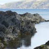
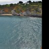
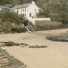
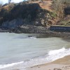
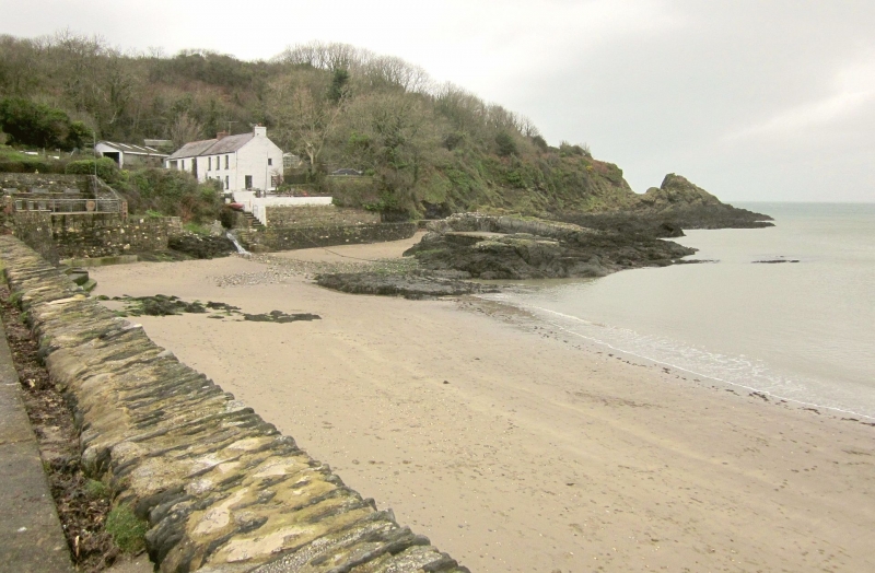
The sand and shingle cove of Cwm yr Eglwys is enclosed by a high protective stone wall, which was likely built in response to the enormous 1859 storm that washed away most of the village's 12th century chapel. Today, all that remains of the church is the end wall with its bell tower. The beach is situated in a sheltered east-facing location, making it an ideal spot for boating and water sports enthusiasts.
Cwm yr Eglwys is popular with boating and water sports enthusiasts due to the slipway and local boat club. The beach is also a hit with younger visitors who will enjoy exploring the little stream and abundant rockpools. Walkers can take the Dinas Circular walk around the peninsula, which takes just over 3 hours to complete.
Cwm yr Eglwys Beach is adjacent to the Pembrokeshire Coast Path and the Wales Coast Path.
Bay Sand Shingle
| Today | |
|---|---|
| Chance of rain | 100% |
| Max temperature | 15°C |
| feels like | 15°C |
| Wind 22mph | |
| Max UV Index |
| Tonight | |
|---|---|
| Chance of rain | 40% |
| Min temperature | 10°C |
| feels like | 10°C |
| Wind 21mph |
The tide at Cwm yr Eglwys Beach is currently rising. High tide will be at approximately 10:23 AM, and the next low tide will be at approximately 4:38 PM.
![]() Today's air pollution levels are forecast to be Low
Today's air pollution levels are forecast to be Low
Parking available near the beach.
Dogs are allowed.
No lifeguard cover at this beach
![]()
Water quality not measured here
Glan Helyg

From £5449.00 per week at Sykes Holiday Cottages
Llaethdy

From £2340.00 per week at Sykes Holiday Cottages
Rose Cottage

From £3062.00 per week at Sykes Holiday Cottages
Snowdrop Cottage

From £2017.00 per week at Sykes Holiday Cottages
Craigluscar

From £2709.00 per week at Sykes Holiday Cottages
Fern Cottage

From £2933.00 per week at Sykes Holiday Cottages
Dyffryn Fernant Gardens (2.3 miles)
Kayak-King (3.7 miles)
Bessies (3.8 miles)
The Last Invasion Tapestry Gallery (4.1 miles)
Theatr Gwaun (4.1 miles)
RockUp-Climbing (4.3 miles)
Ocean Lab (4.4 miles)
Bluestone Brewing Company Ltd (4.4 miles)
Yet-Y-Gors Fishery and Campsite (6 miles)
All distances are approximate
less than a mile west as the seagull flies, just over a mile by road or less than a mile on foot using coastal paths.
around 2 miles east as the seagull flies, around 4 miles by road.
around 2 miles east as the seagull flies, around 7 miles by road or 5 miles on foot using coastal paths.
around 4 miles west-southwest as the seagull flies, around 7 miles by road.
around 4 miles west-southwest as the seagull flies, around 7 miles by road.
around 9 miles west-southwest as the seagull flies, around 13 miles by road.
around 10 miles east-northeast as the seagull flies, around 15 miles by road.
around 10 miles northeast as the seagull flies, around 14 miles by road.
around 11 miles east-northeast as the seagull flies, around 18 miles by road.
around 11 miles west-southwest as the seagull flies, around 14 miles by road.
around 11 miles northeast as the seagull flies, around 19 miles by road.
around 13 miles northeast as the seagull flies, around 21 miles by road.
around 14 miles west-southwest as the seagull flies, around 17 miles by road.
around 15 miles west-southwest as the seagull flies, around 17 miles by road.
around 15 miles west-southwest as the seagull flies, around 17 miles by road.
around 15 miles southwest as the seagull flies, around 18 miles by road.
around 17 miles south-southwest as the seagull flies, around 21 miles by road.
around 17 miles east-northeast as the seagull flies, around 22 miles by road.
around 17 miles south-southwest as the seagull flies, around 22 miles by road.
around 18 miles east-northeast as the seagull flies, around 24 miles by road.
Location: Cwm-yr-Eglwys
Location type: Village
Nearest village: Dinas Cross
OS Grid: SN015400
Coordinates: 52°1'24"N 4°53'37"W
Mapcode: GBR CP.GLSQ
What 3 Words: doubt.national.pimples
Coordinates and location codes are for an approximate mid-point of the beach, and may not reflect the best access point or the most popular part of the beach.
Country: Wales
Local Authority: Pembrokeshire
Parish: Dinas Cross
Nearest postcode: SA42 0SL
(for sat-nav purposes only, a beach does not have a postal address!)
Important! Beach information is compiled from a variety of different sources and is correct to the best of our knowledge at the time of compilation. However, information may be incorrectly supplied by our sources or go out of date after publication. BritishBeaches.uk makes no warranty as to the accuracy of any information on this page.
(Or après-beach. Or pre-beach. Or, just because you might want stuff)
Men's Tops
Weird Fish Giles Pique Polo Shirt Navy Size S

Only £38.00 from Weird Fish