Approximate Location Map
Use two fingers to pan or zoom the map
Use two fingers to pan or zoom the map
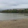
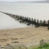
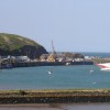
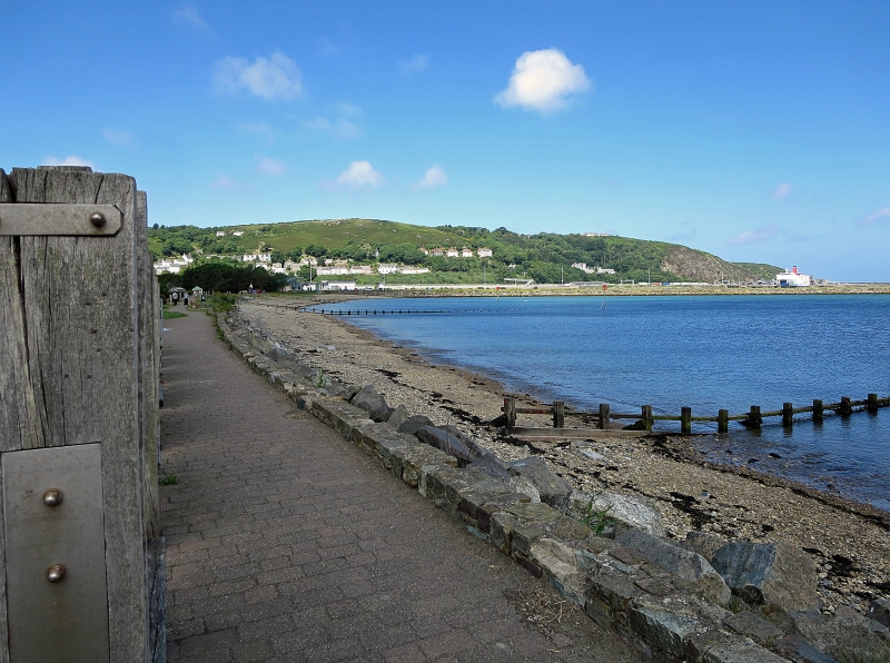
Goodwick Sands is a small sandy beach set in a bay, characterised by a mix of sand and shingle. The beach is situated close to the Fishguard-Rosslare Ferry Terminal, which is linked to London by train. The beach is divided by a series of wooden groynes and features a sea wall composed of quarried boulders, as well as a narrow promenade and a breakwater.
The beach offers a range of activities and features, including the possibility of spotting seals, dolphins, or basking sharks in the water. The shallow waters also make it an ideal spot for observing mussels and other shellfish in the wet sand. In the early evening, the beach can be a good spot for fishing. Visitors can also walk along the breakwater for views of the bay.
Goodwick Sands holds historic significance as the site of the Battle of Fishguard in 1797, where a French Revolutionary invasion force surrendered to defending militia. Local legend tells the story of Jemima Nichols, who rounded up 12 French mercenaries armed only with a pitchfork.
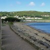
The A40 road runs alongside the beach, with a number of parking spaces available, as well as a larger pay and display car park on the other side of the road. The seaside town of Goodwick, twinned with neighbouring Fishguard, offers additional amenities, including a small shingle beach and a promenade.
Goodwick Sands is adjacent to the Pembrokeshire Coast Path and the Wales Coast Path.
Bay Harbour Sand
| Today | |
|---|---|
| Chance of rain | 100% |
| Max temperature | 15°C |
| feels like | 15°C |
| Wind 22mph | |
| Max UV Index |
| Tonight | |
|---|---|
| Chance of rain | 40% |
| Min temperature | 10°C |
| feels like | 10°C |
| Wind 21mph |
The tide at Goodwick Sands is currently rising. High tide will be at approximately 10:23 AM, and the next low tide will be at approximately 4:38 PM.
![]() Today's air pollution levels are forecast to be Low
Today's air pollution levels are forecast to be Low
Parking is next to the beach.
Dogs are allowed
Beach cleaned daily
No lifeguard cover at this beach
![]()
Water quality not measured here
Seabrook

From £5426.00 per week at Sykes Holiday Cottages
Cockshead Cottage

From £2161.00 per week at Sykes Holiday Cottages
Bwthyn Eisteddfa Fach

From £2921.00 per week at Sykes Holiday Cottages
Hideaway

From £1282.00 per week at Sykes Holiday Cottages
Llety

From £2087.00 per week at Sykes Holiday Cottages
Harmon Vale

From £4723.00 per week at Sykes Holiday Cottages
Ocean Lab (0.1 miles)
Theatr Gwaun (0.6 miles)
RockUp-Climbing (0.6 miles)
The Last Invasion Tapestry Gallery (0.8 miles)
Kayak-King (1 miles)
Yet-Y-Gors Fishery and Campsite (2.2 miles)
Dyffryn Fernant Gardens (2.9 miles)
Melin Tregwynt Woolen Mill (3.8 miles)
Strumble Head (3.9 miles)
Preseli Venture (4.7 miles)
All distances are approximate
less than a mile northwest as the seagull flies, less than a mile by road or less than a mile on foot using coastal paths.
around 4 miles east-northeast as the seagull flies, around 6 miles by road.
around 4 miles east-northeast as the seagull flies, around 6 miles by road.
around 5 miles west-southwest as the seagull flies, around 8 miles by road or 6 miles on foot using coastal paths.
around 7 miles west-southwest as the seagull flies, around 9 miles by road.
around 7 miles east-northeast as the seagull flies, around 9 miles by road.
around 7 miles east-northeast as the seagull flies, around 11 miles by road.
around 10 miles west-southwest as the seagull flies, around 12 miles by road.
around 10 miles west-southwest as the seagull flies, around 12 miles by road.
around 10 miles west-southwest as the seagull flies, around 12 miles by road.
around 12 miles south-southwest as the seagull flies, around 14 miles by road.
around 13 miles south-southwest as the seagull flies, around 16 miles by road.
around 14 miles south-southwest as the seagull flies, around 17 miles by road.
around 14 miles southwest as the seagull flies, around 16 miles by road.
around 14 miles east-northeast as the seagull flies, around 18 miles by road.
around 14 miles east-northeast as the seagull flies, around 20 miles by road.
around 15 miles east-northeast as the seagull flies, around 23 miles by road.
around 15 miles west-southwest as the seagull flies, around 17 miles by road.
around 15 miles east-northeast as the seagull flies, around 23 miles by road.
around 15 miles southwest as the seagull flies, around 17 miles by road.
Location: Wdig (Goodwick)
Location type: Town
OS Grid: SM948378
Coordinates: 52°0'3"N 4°59'23"W
Mapcode: GBR CK.J0Z6
What 3 Words: blink.mimed.plea
Coordinates and location codes are for an approximate mid-point of the beach, and may not reflect the best access point or the most popular part of the beach.
Country: Wales
Local Authority: Pembrokeshire
Parish: Fishguard and Goodwick
Nearest postcode: SA65 9PN
(for sat-nav purposes only, a beach does not have a postal address!)
Important! Beach information is compiled from a variety of different sources and is correct to the best of our knowledge at the time of compilation. However, information may be incorrectly supplied by our sources or go out of date after publication. BritishBeaches.uk makes no warranty as to the accuracy of any information on this page.
(Or après-beach. Or pre-beach. Or, just because you might want stuff)
Men's Tops
Weird Fish Sontee Full Zip Macaroni Sweatshirt Navy Size 12

Only £60.00 from Weird Fish