Approximate Location Map
Use two fingers to pan or zoom the map
Use two fingers to pan or zoom the map
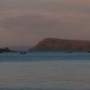
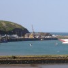
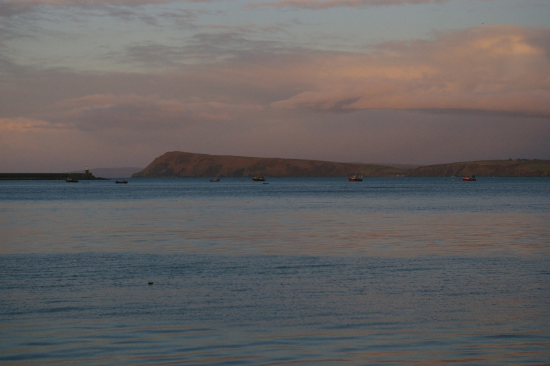
Goodwick Harbour South Beach is situated within the walls of Fishguard Harbour, from where a ferry service operates to Rosslare in Ireland. The beach is separated from Goodwick Sands by the harbour wall. At low tide, the beach is popular for walking, swimming, water sports, and watching the ferries entering and leaving the harbour. However, at high tide, the sandy part of the beach is completely submerged.
The beach can be accessed via a slipway, and a car park is located directly behind it. Public toilets and a watersports centre are also available, along with a promenade featuring benches facing the sea. A small retail park with shops and places to eat can be found across the road from the beach. The nearest railway station, Fishguard and Goodwick Railway Station, is a short walk away.
The seaside town of Goodwick, twinned with neighbouring Fishguard, offers a small shingle beach on the south side of the sea wall. A promenade backs the beach, and a long sea wall provides an opportunity for a scenic walk. Visitors can enjoy fish and chips on the beach or take a walk along the Goodwick Sea Wall for panoramic views of the area. The Fishguard Ferry Port, which operates the Fishguard to Rosslare ferry, is located just north of the beach.
Bay Harbour Sand
| Today | |
|---|---|
| Chance of rain | 100% |
| Max temperature | 15°C |
| feels like | 15°C |
| Wind 22mph | |
| Max UV Index |
| Tonight | |
|---|---|
| Chance of rain | 48% |
| Min temperature | 10°C |
| feels like | 10°C |
| Wind 22mph |
The tide at Goodwick Harbour South Beach is currently falling. Low tide will be at approximately 4:38 PM, and the next high tide will be at approximately 10:42 PM.
![]() Today's air pollution levels are forecast to be Low
Today's air pollution levels are forecast to be Low
Parking is next to the beach.
Dogs are allowed.
Beach cleaned daily.
No lifeguard cover at this beach
Water quality not measured here
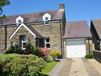
Hideaway

From £1282.00 per week at Sykes Holiday Cottages
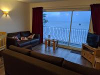
Valley High

From £2198.00 per week at Sykes Holiday Cottages
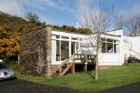
Coastal Dyfed House
From £874.00 per week at Holidaycottages.co.uk
Dyfed Cottage
From £500.00 per week at Holidaycottages.co.uk
Coastal Dyfed Apartment
From £494.00 per week at Holidaycottages.co.uk
Rural Dyfed Apartment
From £407.00 per week at Holidaycottages.co.uk
Ocean Lab (0.1 miles)
RockUp-Climbing (0.5 miles)
Theatr Gwaun (0.8 miles)
The Last Invasion Tapestry Gallery (0.9 miles)
Kayak-King (1.1 miles)
Yet-Y-Gors Fishery and Campsite (2.3 miles)
Dyffryn Fernant Gardens (3 miles)
Strumble Head (3.8 miles)
Melin Tregwynt Woolen Mill (3.8 miles)
Preseli Venture (4.7 miles)
All distances are approximate
less than a mile southeast as the seagull flies, less than a mile by road.
around 4 miles east-northeast as the seagull flies, around 7 miles by road.
around 4 miles east-northeast as the seagull flies, around 7 miles by road.
around 5 miles west-southwest as the seagull flies, around 7 miles by road or 6 miles on foot using coastal paths.
around 7 miles west-southwest as the seagull flies, around 8 miles by road.
around 7 miles east-northeast as the seagull flies, around 9 miles by road.
around 7 miles east-northeast as the seagull flies, around 11 miles by road.
around 10 miles west-southwest as the seagull flies, around 12 miles by road.
around 10 miles west-southwest as the seagull flies, around 12 miles by road.
around 10 miles west-southwest as the seagull flies, around 12 miles by road.
around 12 miles south-southwest as the seagull flies, around 13 miles by road.
around 13 miles south-southwest as the seagull flies, around 16 miles by road.
around 14 miles south-southwest as the seagull flies, around 17 miles by road.
around 14 miles southwest as the seagull flies, around 16 miles by road.
around 14 miles east-northeast as the seagull flies, around 18 miles by road.
around 14 miles east-northeast as the seagull flies, around 20 miles by road.
around 15 miles east-northeast as the seagull flies, around 23 miles by road.
around 15 miles west-southwest as the seagull flies, around 17 miles by road.
around 15 miles east-northeast as the seagull flies, around 24 miles by road.
around 15 miles southwest as the seagull flies, around 17 miles by road.
Location: Wdig (Goodwick)
Location type: Town
OS Grid: SM947380
Coordinates: 52°0'10"N 4°59'30"W
Mapcode: GBR CK.HSKY
What 3 Words: voices.tigers.direction
Coordinates and location codes are for an approximate mid-point of the beach, and may not reflect the best access point or the most popular part of the beach.
Country: Wales
Local Authority: Pembrokeshire
Parish: Fishguard and Goodwick
Nearest postcode: SA64 0DE
(for sat-nav purposes only, a beach does not have a postal address!)
Important! Beach information is compiled from a variety of different sources and is correct to the best of our knowledge at the time of compilation. However, information may be incorrectly supplied by our sources or go out of date after publication. BritishBeaches.uk makes no warranty as to the accuracy of any information on this page.
(Or après-beach. Or pre-beach. Or, just because you might want stuff)
Women's Outerwear
Weird Fish Sena Printed Waterproof Coat Nightshade Size 16

Only £90.00 from Weird Fish