Approximate Location Map
Use two fingers to pan or zoom the map
Use two fingers to pan or zoom the map
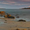
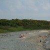
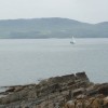
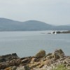
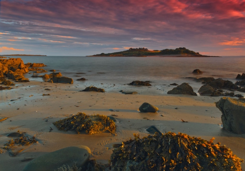
Carrick Beach is a small, sandy bay situated at the north-eastern end of a larger bay, Fleet Bay. The beach is separated from the rest of Fleet Bay by a rocky headland, approximately 200 meters long. The beach can be accessed via a track road, which leads down to the shore. The bay itself is about 100 meters wide and offers excellent views of the surrounding wild and mountainous headlands and coastline.
The sheltered bay is suitable for bathing and water sports, such as canoeing. However, the area is primarily popular for its walking opportunities, with many coastal paths and the nearby Galloway Forest National Park. Visitors are allowed to bring their dogs onto the beach. Some roadside parking is available near the beach, but facilities are limited, so it is recommended to bring a picnic.
Due to its remoteness, Carrick Beach is rarely busy, making it an ideal spot for those seeking a peaceful and secluded experience. Visitors should be prepared for a lack of facilities and plan accordingly.
Bay Sand
| Today | |
|---|---|
| Chance of rain | 99% |
| Max temperature | 14°C |
| feels like | 14°C |
| Wind 21mph | |
| Max UV Index |
| Tonight | |
|---|---|
| Chance of rain | 84% |
| Min temperature | 9°C |
| feels like | 9°C |
| Wind 18mph |
The tide at Carrick Beach is currently rising. High tide will be at approximately 2:18 AM, and the next low tide will be at approximately 8:37 AM.
![]() Today's air pollution levels are forecast to be Low
Today's air pollution levels are forecast to be Low
Limited roadside parking.
Dogs are allowed
No lifeguard cover at this beach
Excellent water quality
Luxury Romantic Dumfries And Galloway Cottage

From £922.00 per week at Holidaycottages.co.uk
Old Sawmill Cottage

From £1266.00 per week at Sykes Holiday Cottages
The Paddock

From £1847.00 per week at Sykes Holiday Cottages
Dumfries And Galloway Cottage

From £940.00 per week at Holidaycottages.co.uk
Bracken Holiday Cottage

From £1592.00 per week at Sykes Holiday Cottages
Gate Lodge - Threave Estate

From £3318.00 per week at Sykes Holiday Cottages
Cream O' Galloway (1.6 miles)
Mossyard Farm Pottery (1.9 miles)
Laggan Outdoor (2.6 miles)
Cardoness Castle (3 miles)
Cally Gardens (3 miles)
The Mill on the Fleet (3.8 miles)
Cairnholy Chambered Cairns Ravenshall (4.2 miles)
Brighouse Bay (4.9 miles)
All distances are approximate
around 2 miles west-northwest as the seagull flies, around 9 miles by road.
around 5 miles southeast as the seagull flies, around 8 miles by road.
around 5 miles east as the seagull flies, around 7 miles by road.
around 15 miles west-southwest as the seagull flies, around 39 miles by road.
around 17 miles east as the seagull flies, around 29 miles by road.
around 20 miles east as the seagull flies, around 29 miles by road.
around 25 miles east as the seagull flies, around 36 miles by road.
around 28 miles east-southeast as the seagull flies, around 101 miles by road.
around 29 miles west-southwest as the seagull flies, around 55 miles by road.
around 29 miles east-southeast as the seagull flies, around 102 miles by road.
around 29 miles west as the seagull flies, around 45 miles by road.
around 29 miles east-southeast as the seagull flies, around 95 miles by road.
around 30 miles west-southwest as the seagull flies, around 51 miles by road.
Location: Carrick Shore
Location type: Village
OS Grid: NX577506
Coordinates: 54°49'48"N 4°13'0"W
Mapcode: GBR HHYY.C63
What 3 Words: venturing.half.vacancies
Coordinates and location codes are for an approximate mid-point of the beach, and may not reflect the best access point or the most popular part of the beach.
Country: Scotland
Local Authority: Dumfries and Galloway
Nearest postcode: DG7 2DT
(for sat-nav purposes only, a beach does not have a postal address!)
Important! Beach information is compiled from a variety of different sources and is correct to the best of our knowledge at the time of compilation. However, information may be incorrectly supplied by our sources or go out of date after publication. BritishBeaches.uk makes no warranty as to the accuracy of any information on this page.
(Or après-beach. Or pre-beach. Or, just because you might want stuff)
Men's Tops
Weird Fish Chicoa Full Zip Macaroni Hoodie Adriatic Blue Size 20

Only £48.00 from Weird Fish