Approximate Location Map
Use two fingers to pan or zoom the map
Use two fingers to pan or zoom the map
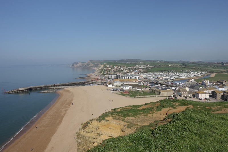
West Bay East Beach, also known as East Beach, forms the western end of the vast Chesil Beach and stretches towards the harbour at West Bay. The beach is primarily composed of fine shingle, with areas of sand near the water's edge. The shoreline slopes quite steeply into the sea, making it essential for visitors to exercise caution.
The beach is backed by majestic sandstone cliffs, known as East Cliff, which rise almost 50 metres (180ft) vertically above the shoreline. However, these cliffs can be unstable, and visitors are advised to observe the various warning signs and safety posters around the beach. The steep shelving of the water makes West Beach, located on the other side of the harbour, a potentially safer option for children to play in the water.
East Beach is an ideal destination for beachcombing walks and fossil hunting, given its wide expanse of coast. The beach has been designated a Site of Special Scientific Interest, and there are several walking paths in the vicinity. The beach and surrounding area were also used as a filming location for the popular TV series Broadchurch.
The nearby harbour at West Bay has spaces for around 70 boats and offers a variety of amenities, including fish and chip shops, cafes, and restaurants. The beach is backed by the Bridport & West Dorset Golf Club, and there is parking available nearby. Visitors should note that dog restrictions apply to certain areas of the beach, with dogs allowed all year on the East Cliff area, but restricted from May to September to the west of East Cliff.
West Bay East Beach is on the Jurassic Coast, and adjacent to the South West Coast Path.
Harbour Sand Shingle
| Today | |
|---|---|
| Chance of rain | 91% |
| Max temperature | 16°C |
| feels like | 16°C |
| Wind 20mph | |
| Max UV Index |
| Tonight | |
|---|---|
| Chance of rain | 24% |
| Min temperature | 10°C |
| feels like | 11°C |
| Wind 19mph |
The tide at West Bay East Beach is currently falling. Low tide will be at approximately 2:43 AM, and the next high tide will be at approximately 9:29 AM.
![]() Today's air pollution levels are forecast to be Low
Today's air pollution levels are forecast to be Low
Car parking is available.
Dogs not allowed May 1st to September 30th.
The beach is regularly cleaned by West Dorset District Council.
Daily - 9th July - 4th September
Water quality not measured here
Everdene

From £3567.00 per week at Sykes Holiday Cottages
Little Bay View

From £2064.00 per week at Sykes Holiday Cottages
Bay View

From £2784.00 per week at Sykes Holiday Cottages
Romantic Rural Dorset Cottage

From £770.00 per week at Holidaycottages.co.uk
Dorset Cottage

From £610.00 per week at Holidaycottages.co.uk
South Lodge

From £1920.00 per week at Sykes Holiday Cottages
Lyme Bay Rib Charter (0.1 miles)
West Bay Canoes (0.2 miles)
Palmers Brewery (1.2 miles)
Reboot Dorset (2.4 miles)
Golden Cap Estate (3.8 miles)
Jurassic Electric Bike Adventures (4.8 miles)
Seagulls Restaurant (240 yards)
West Bay Tea Rooms (340 yards)
Baboo Gelato Ltd (180 yards)
Rachel's (90 yards)
All distances are approximate
less than a mile west-northwest as the seagull flies, less than a mile by road.
just over a mile west-northwest as the seagull flies, around 3 miles by road or 2 miles on foot using coastal paths.
around 2 miles east-southeast as the seagull flies, around 2 miles by road.
around 3 miles west-northwest as the seagull flies, around 5 miles by road or 4 miles on foot using coastal paths.
around 6 miles west-northwest as the seagull flies, around 9 miles by road.
around 6 miles west-northwest as the seagull flies, around 9 miles by road.
around 8 miles west as the seagull flies, around 11 miles by road.
around 8 miles west as the seagull flies, around 12 miles by road.
around 8 miles west as the seagull flies, around 12 miles by road.
around 14 miles west as the seagull flies, around 20 miles by road.
around 14 miles west as the seagull flies, around 21 miles by road.
around 15 miles southeast as the seagull flies, around 18 miles by road.
around 15 miles east-southeast as the seagull flies, around 18 miles by road.
around 15 miles east-southeast as the seagull flies, around 18 miles by road.
around 15 miles east-southeast as the seagull flies, around 23 miles by road.
around 15 miles east-southeast as the seagull flies, around 19 miles by road.
around 15 miles east-southeast as the seagull flies, around 18 miles by road.
around 15 miles east-southeast as the seagull flies, around 22 miles by road.
around 16 miles east-southeast as the seagull flies, around 23 miles by road.
around 16 miles west as the seagull flies, around 23 miles by road.
Location: West Bay, Bridport
Location type: Urban
OS Grid: SY463902
Coordinates: 50°42'33"N 2°45'38"W
Mapcode: GBR PP.1Y4F
What 3 Words: laugh.firewall.event
Coordinates and location codes are for an approximate mid-point of the beach, and may not reflect the best access point or the most popular part of the beach.
County: Dorset
Country: England
Local Authority: West Dorset
Parish: Bridport
Nearest postcode: DT6 4EP
(for sat-nav purposes only, a beach does not have a postal address!)
Important! Beach information is compiled from a variety of different sources and is correct to the best of our knowledge at the time of compilation. However, information may be incorrectly supplied by our sources or go out of date after publication. BritishBeaches.uk makes no warranty as to the accuracy of any information on this page.
(Or après-beach. Or pre-beach. Or, just because you might want stuff)
Men's Tops
Weird Fish Mountain Valley Back Print Graphic T-Shirt Aubergine Size L

Only £28.00 from Weird Fish


