Approximate Location Map
Use two fingers to pan or zoom the map
Use two fingers to pan or zoom the map
Dovercourt Beach features low, wooden groynes and is backed by a sea wall, with a promenade that extends to Harwich Town. The beach is a peaceful family resort with gentle shelving sand and shingle areas, including the historic leading lights.
The promenade offers a wide range of family activities, including sport and leisure facilities such as a skate park, model yacht pond, and boating lake. Visitors can enjoy panoramic views of Harwich, the port of Felixstowe, and Hamford Water National Nature Reserve. The beach is also home to beach huts and a variety of cafes and restaurants.
At the eastern end of the beach, the promenade loops round Cornwallis Battery to join Harwich beach to the north. Visitors can take a stroll around the narrow streets in the historic old town of Harwich or walk along the seawall to the nature reserve, which is home to resident seals.
Dovercourt Bay Beach is a popular Blue Flag beach and a favourite family holiday destination. The beach is mostly dog-friendly, although there are some restricted areas from May 1st to September 30 each year.
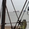
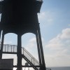
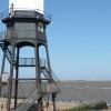
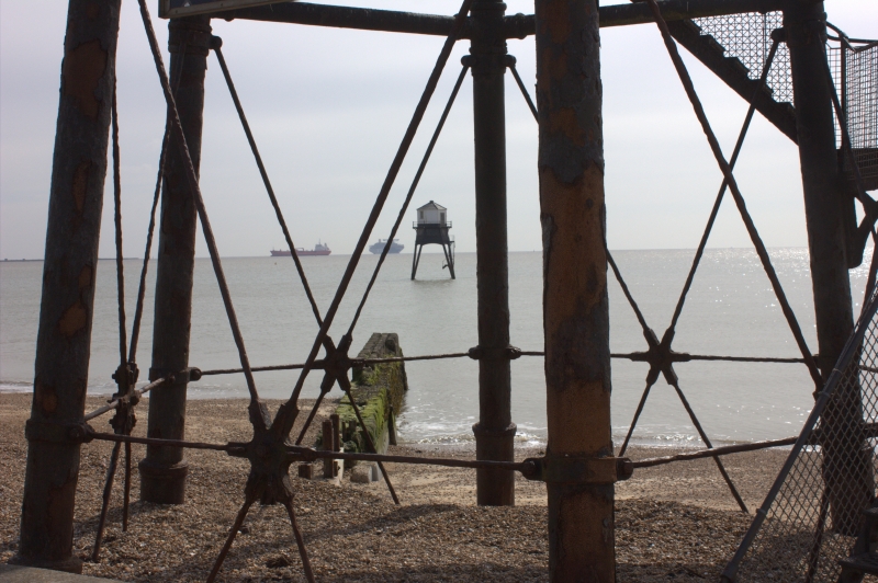
The Dovercourt lighthouses, commonly referred to as the High Lighthouse and the Low Lighthouse, are unique structures built on cast iron legs and joined by a causeway. The beach was also the location for the Holiday Park in the classic 1980s BBC sitcom Hi-De-Hi, and visitors can see a dedicated display at the Harwich Museum.
On the eastern end of the beach is Cliff Park, a lovely open space with a children's playground and places to sit and relax on the seafront. Visitors can rent a beach hut or head to the boating lake, along Lower Marine Road.
Sand
| Today | |
|---|---|
| Chance of rain | 76% |
| Max temperature | 17°C |
| feels like | 17°C |
| Wind 20mph | |
| Max UV Index |
| Tonight | |
|---|---|
| Chance of rain | 34% |
| Min temperature | 11°C |
| feels like | 12°C |
| Wind 16mph |
The tide at Dovercourt Beach is currently high. Low tide will be at approximately 8:20 AM, and the next high tide will be at approximately 2:47 PM.
![]() Today's air pollution levels are forecast to be Low
Today's air pollution levels are forecast to be Low
Free and Pay and Display car parking is available. Low Road Car Park is to the south of the beach.
Dogs not allowed May 1st to September 30th.
Beach cleaned daily during the summer.
No information available
![]()
![]()
Excellent water quality
Ivy Cottage

From £1789.00 per week at Sykes Holiday Cottages
The Bungalow

From £1050.00 per week at Sykes Holiday Cottages
King George Penthouse

From £3862.00 per week at Sykes Holiday Cottages
Sandlings

From £2199.00 per week at Sykes Holiday Cottages
Aldeburgh Cottage

From £2735.00 per week at Sykes Holiday Cottages
Old Felixstowe, Bath Road

From £1980.00 per week at Sykes Holiday Cottages
Harwich Redoubt Fort (0.6 miles)
Electric Palace (0.8 miles)
Halfpenny Pier (0.9 miles)
Lightvessel LV18 (0.9 miles)
Stena Line (1.6 miles)
Landguard Fort (1.7 miles)
Felixstowe Museum (2 miles)
Felixstowe Seafront Gardens (3.3 miles)
Port of Felixstowe (3.7 miles)
Treo Bar Cafe (430 yards)
Thai Up At The Quay (230 yards)
The Alma Inn and Dining Rooms (200 yards)
The Cafe on the Pier (150 yards)
All distances are approximate
less than a mile northeast as the seagull flies, less than a mile by road.
less than a mile north as the seagull flies, just over a mile by road or less than a mile on foot using coastal paths.
around 6 miles south as the seagull flies, around 15 miles by road.
around 8 miles south as the seagull flies, around 15 miles by road.
around 9 miles south-southwest as the seagull flies, around 15 miles by road.
around 11 miles south-southwest as the seagull flies, around 17 miles by road.
around 12 miles south-southwest as the seagull flies, around 18 miles by road.
around 12 miles south-southwest as the seagull flies, around 19 miles by road.
around 13 miles south-southwest as the seagull flies, around 20 miles by road.
around 15 miles southwest as the seagull flies, around 19 miles by road.
around 3 miles east-northeast as the seagull flies, around 32 miles by road or 5 miles on foot using coastal paths.
around 4 miles east-northeast as the seagull flies, around 32 miles by road or 6 miles on foot using coastal paths.
around 19 miles southwest as the seagull flies, around 27 miles by road.
around 20 miles northeast as the seagull flies, around 48 miles by road or 29 miles on foot using coastal paths.
around 28 miles north-northeast as the seagull flies, around 54 miles by road or 36 miles on foot using coastal paths.
Location: Dovercourt, Harwich
Location type: Urban
OS Grid: TM256313
Coordinates: 51°56'6"N 1°16'53"E
Mapcode: GBR VQR.LVN
What 3 Words: once.match.glorified
Coordinates and location codes are for an approximate mid-point of the beach, and may not reflect the best access point or the most popular part of the beach.
County: Essex
Country: England
Local Authority: Tendring
Parish: Harwich
Nearest postcode: CO12 3JY
(for sat-nav purposes only, a beach does not have a postal address!)
Important! Beach information is compiled from a variety of different sources and is correct to the best of our knowledge at the time of compilation. However, information may be incorrectly supplied by our sources or go out of date after publication. BritishBeaches.uk makes no warranty as to the accuracy of any information on this page.
(Or après-beach. Or pre-beach. Or, just because you might want stuff)
Women's Outerwear
Weird Fish Eshka Lightweight Padded Jacket Navy Blue Size 18

Only £60.00 from Weird Fish