Approximate Location Map
Use two fingers to pan or zoom the map
Use two fingers to pan or zoom the map
Amble Links Beach is situated close to Amble harbour and marina, and is a popular destination for bird watchers, coastal walkers, and families. The beach is approximately one kilometre long and features a gently sloping sandy shoreline, with some areas of shingle and rocks. The beach is backed by cliffs, with Park Leisure Amble Links Holiday Park located behind it.
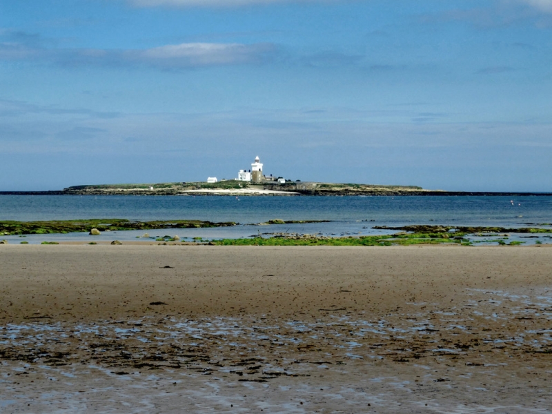
The beach is favoured by bird twitchers and coastal walkers, and dogs are allowed on the beach. Families are also drawn to the beach, particularly to explore the rock pools at low tide, which are home to a variety of shore-life. Water sports such as surfing and kayaking are also popular activities at Amble Links Beach. Visitors can also take boat trips to Coquet Island, which is home to a large colony of puffins and features a working lighthouse and the ruins of an ancient monastery.
Nearby Low Hauxley is home to the remains of a pre-historic submerged forest, where tree stumps preserved in peat, possibly 7000 years old, are occasionally exposed by the tides. These remains are thought to be part of Doggerland, a stretch of land which once connected Britain to the European land mass. Archaeologists have discovered evidence of human habitation in the area from thousands of years BC, along with bear and wild boar footprints.
There is free parking available on the cliffs above the beach, as well as toilets. The beach is accessed via a gentle but narrow path. The adjacent village of Amble offers a range of shops, pubs, and restaurants.
The lighthouse on Coquet Island was manned by the brother of the famous Northumbrian Heroine Grace Darling. Amble Links Beach is a seven-mile stretch of sand, rock, and shingle, east of the harbour, and is backed by grassy dunes, providing plenty of space to roam.
Amble Links Beach is on the North Northumberland Heritage Coast, and adjacent to the Northumberland Coast Path.
Sand Shingle
| Today |  |
|---|---|
| Chance of rain | 19% |
| Max temperature | 17°C |
| feels like | 17°C |
| Wind 11mph |  |
| Max UV Index |  |
| Tonight |  |
|---|---|
| Chance of rain | 75% |
| Min temperature | 13°C |
| feels like | 11°C |
| Wind 13mph | |
The tide at Amble Links Beach is currently falling. Low tide will be at approximately 1:09 PM, and the next high tide will be at approximately 7:15 PM.
 Today's air pollution levels are forecast to be Low
 Toilets
Free parking near the beach.
Dogs are allowed.
No lifeguard cover at this beach


Good water quality
around 2 miles northwest as the seagull flies, around 5 miles by road.
around 2 miles south-southwest as the seagull flies, around 4 miles by road or 3 miles on foot using coastal paths.
around 5 miles south as the seagull flies, around 8 miles by road or 5 miles on foot using coastal paths.
around 5 miles north-northwest as the seagull flies, around 9 miles by road.
around 6 miles south as the seagull flies, around 9 miles by road or 7 miles on foot using coastal paths.
around 6 miles south as the seagull flies, around 9 miles by road or 7 miles on foot using coastal paths.
around 7 miles south as the seagull flies, around 12 miles by road or 8 miles on foot using coastal paths.
around 8 miles north as the seagull flies, around 12 miles by road.
around 9 miles south as the seagull flies, around 13 miles by road or 10 miles on foot using coastal paths.
around 9 miles south-southeast as the seagull flies, around 14 miles by road or 11 miles on foot using coastal paths.
around 10 miles south as the seagull flies, around 14 miles by road.
around 10 miles south as the seagull flies, around 14 miles by road.
around 10 miles north as the seagull flies, around 16 miles by road.
around 12 miles south as the seagull flies, around 18 miles by road.
around 12 miles south as the seagull flies, around 18 miles by road.
around 13 miles north-northwest as the seagull flies, around 19 miles by road.
around 15 miles south as the seagull flies, around 22 miles by road.
around 16 miles north-northwest as the seagull flies, around 22 miles by road.
around 17 miles south as the seagull flies, around 23 miles by road.
around 17 miles north-northwest as the seagull flies, around 22 miles by road.
Location: Low Hauxley
Location type: Village
OS Grid: NU285035
Coordinates: 55°19'29"N 1°33'5"W
Mapcode: GBR K6LW.X1
What 3 Words: workers.zebra.butterfly
Coordinates and location codes are for an approximate mid-point of the beach, and may not reflect the best access point or the most popular part of the beach.
Country: England
Local Authority: Northumberland
Parish: Hauxley
Nearest postcode: NE65 0JT
(for sat-nav purposes only, a beach does not have a postal address!)
Important! Beach information is compiled from a variety of different sources and is correct to the best of our knowledge at the time of compilation. However, information may be incorrectly supplied by our sources or go out of date after publication. BritishBeaches.uk makes no warranty as to the accuracy of any information on this page.