Approximate Location Map
Use two fingers to pan or zoom the map
Use two fingers to pan or zoom the map
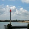
Shoreham-by-Sea is situated on the West Sussex coast, approximately midway between Worthing and Brighton. The town has a long history, with some form of harbour present since Roman times. Kingston Beach is situated within this harbour, where the River Adur flows into the sea. The beach itself is composed of shingle and gravel, with several wooden groynes sloping into the sea. At low tide, a small area of wet sand and gravel is exposed.
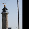
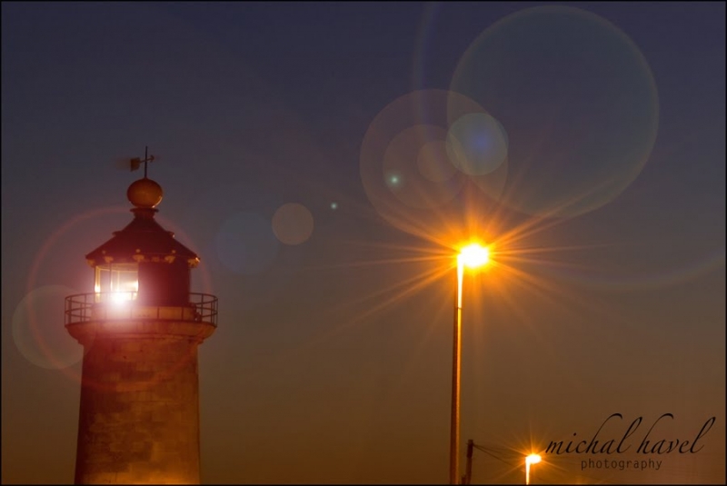
Visitors to Shoreham Kingston Beach come to walk, fish, and enjoy water sports, although there is no zoning for water sports and no lifeguard cover. Behind the beach is a small area of sand, on which stands the Kingston Lighthouse, a working structure originally built in the mid-19th century. The RNLI Shoreham lifeboat station is located adjacent to the beach. The harbour is used by a mix of commercial and leisure vessels.
At the entrance to the harbour, across from the beach, are the remains of Shoreham Redoubt, a fort built in Victorian times on the orders of Lord Palmerston to guard against the perceived threat of an invasion from France. For those looking to explore further, Southwick beach is located just east of Shoreham beach, on the border of East and West Sussex. Southwick beach is predominantly pebbled with some sand at low tide and is safe for swimming, with a designated swimming zone marked with buoys each year between May and the end of September.
The River Adur flows out to sea at the boundary between Southwick and Shoreham-by-Sea. Visitors can stop for refreshments at the Carats Cafe Bar on the seafront.
Shingle Rock
| Today | |
|---|---|
| Chance of rain | 83% |
| Max temperature | 16°C |
| feels like | 16°C |
| Wind 27mph |
| Tonight | |
|---|---|
| Chance of rain | 51% |
| Min temperature | 12°C |
| feels like | 12°C |
| Wind 21mph |
The tide at Shoreham Kingston Beach is currently falling. Low tide will be at approximately 8:21 AM, and the next high tide will be at approximately 2:26 PM.
![]() Today's air pollution levels are forecast to be Low
Today's air pollution levels are forecast to be Low
Parking near Carats Cafe Bar.
Dogs are allowed.
No lifeguard cover at this beach
Water quality not measured here
7 Coastguard Cottages

From £3360.00 per week at Sykes Holiday Cottages
Newstead Farmhouse

From £3120.00 per week at Sykes Holiday Cottages
The Old Dairy

From £2080.00 per week at Sykes Holiday Cottages
The Yeoman's House

From £3424.00 per week at Sykes Holiday Cottages
Luxury East Sussex Cottage
From £2053.00 per week at Holidaycottages.co.uk
Romantic Rural West Sussex Barn

From £660.00 per week at Holidaycottages.co.uk
Shoreham Harbour Lifeboat Station (0.3 miles)
Virtual Aerospace (1.8 miles)
HeliFly UK Ltd (2 miles)
The Therapy Shop (3.2 miles)
TeamSport Go Karting Brighton (3.8 miles)
Pier Pressure Brighton Escape Rooms (4.3 miles)
Hatt Adventures (4.6 miles)
Gustamps (4.6 miles)
Brighton & Beyond Tours (4.6 miles)
Oliver's Brighton (4.6 miles)
All distances are approximate
less than a mile east as the seagull flies, around 8 miles by road or less than a mile on foot using coastal paths.
less than a mile west as the seagull flies, less than a mile by road.
around 2 miles east as the seagull flies, around 6 miles by road or 2 miles on foot using coastal paths.
around 3 miles west as the seagull flies, around 4 miles by road.
around 3 miles east as the seagull flies, around 7 miles by road or 3 miles on foot using coastal paths.
around 4 miles east as the seagull flies, around 8 miles by road or 5 miles on foot using coastal paths.
around 5 miles east as the seagull flies, around 9 miles by road or 6 miles on foot using coastal paths.
around 6 miles west-southwest as the seagull flies, around 6 miles by road.
around 6 miles east as the seagull flies, around 10 miles by road or 6 miles on foot using coastal paths.
around 6 miles west-southwest as the seagull flies, around 7 miles by road.
around 8 miles west-southwest as the seagull flies, around 9 miles by road.
around 9 miles east-southeast as the seagull flies, around 19 miles by road or 9 miles on foot using coastal paths.
around 12 miles west as the seagull flies, around 14 miles by road.
around 13 miles west as the seagull flies, around 15 miles by road.
around 13 miles west as the seagull flies, around 16 miles by road.
around 13 miles east-southeast as the seagull flies, around 27 miles by road or 14 miles on foot using coastal paths.
around 14 miles east-southeast as the seagull flies, around 27 miles by road or 15 miles on foot using coastal paths.
around 15 miles east-southeast as the seagull flies, around 28 miles by road or 17 miles on foot using coastal paths.
around 16 miles west as the seagull flies, around 20 miles by road.
around 18 miles west as the seagull flies, around 21 miles by road.
Location: Southwick
Location type: Urban
OS Grid: TQ236046
Coordinates: 50°49'40"N 0°14'44"W
Mapcode: GBR JNZ.4NV
What 3 Words: divisions.years.aspect
Coordinates and location codes are for an approximate mid-point of the beach, and may not reflect the best access point or the most popular part of the beach.
County: West Sussex
Country: England
Local Authority: Adur
Nearest postcode: BN4 6RG
(for sat-nav purposes only, a beach does not have a postal address!)
Important! Beach information is compiled from a variety of different sources and is correct to the best of our knowledge at the time of compilation. However, information may be incorrectly supplied by our sources or go out of date after publication. BritishBeaches.uk makes no warranty as to the accuracy of any information on this page.
(Or après-beach. Or pre-beach. Or, just because you might want stuff)
Women's Trousers
Weird Fish Nalani Printed Viscose Jumpsuit Tango Red Size 22

Only £42.00 from Weird Fish