Approximate Location Map
Use two fingers to pan or zoom the map
Use two fingers to pan or zoom the map
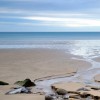
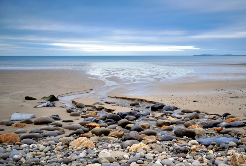
Amroth Beach is a vast sandy beach backed by cobble banks and cliffs, with a promenade overlooking the beach and the Pembrokeshire Coast Path running past the beach. The beach is situated at the start/end of the 186-mile Pembrokeshire Coast Path and is marked by a symbolic signpost. The westernmost point of the beach marks the beginning of the Pembrokeshire Coast National Park.
The beach boasts a long stretch of golden sand, which expands into a vast, flat expanse at low tide, perfect for beach games, walking, or simply taking in the scenery. At high tide, the sandy area shrinks, revealing a pebble bank above the shoreline. The beach also features rockpools at the western end, a concrete slipway, and ramped paths, making it wheelchair-friendly in parts. A lifeguard is present on the beach from the beginning of July to the end of September.
Amroth Beach offers a range of activities, including beach games, fossil hunting, and horse riding. The beach is easily accessible, with level access from the promenade and seafront parking, making it a good choice for visitors with mobility concerns, prams, or wheelchairs. The beach is also a popular spot for walkers, with the Pembrokeshire Coast Path running along the beach.
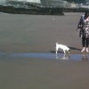
Dogs are not allowed on the central section of the beach from May 1st to September 30th, but the western and eastern ends remain dog-friendly all year. Visitors are advised to check signs for clarity.
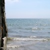
Amroth Beach is adjacent to the Pembrokeshire Coast Path and the Wales Coast Path.
Sand Pebbles
| Today | |
|---|---|
| Chance of rain | 99% |
| Max temperature | 16°C |
| feels like | 16°C |
| Wind 24mph | |
| Max UV Index |
| Tonight | |
|---|---|
| Chance of rain | 40% |
| Min temperature | 10°C |
| feels like | 11°C |
| Wind 23mph |
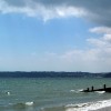
The tide at Amroth Beach is currently falling. Low tide will be at approximately 3:00 AM, and the next high tide will be at approximately 9:06 AM.
![]() Today's air pollution levels are forecast to be Low
Today's air pollution levels are forecast to be Low
Free parking is available for 60 cars, including disabled spaces on the sea front.
Dogs not allowed on certain areas May 1st to September 30th please see local Notice boards.
Beach cleaned daily.
Daily - 2nd July - 4th September
![]()
![]()
Excellent water quality
Coastal Dyfed Apartment
From £802.00 per week at Holidaycottages.co.uk
Luxury Rural Cosheston Farmhouse

From £1921.00 per week at Holidaycottages.co.uk
Panteurig Farmhouse

From £2071.00 per week at Sykes Holiday Cottages
Barn Cottage

From £2159.00 per week at Sykes Holiday Cottages
Romantic Rural Dyfed Farm Cottage

From £549.00 per week at Holidaycottages.co.uk
Panteurig Cottage

From £1619.00 per week at Sykes Holiday Cottages
Colby Woodland Garden (National Trust) (0.8 miles)
Wisemans Bridge (1.2 miles)
The Reptile Experience (2.3 miles)
Marros Riding Centre (2.7 miles)
Folly Farm (3.3 miles)
Morfa Bay Adventure (4.2 miles)
Tenby Museum and Art Gallery (4.3 miles)
Tenby Boat Trips (4.3 miles)
The Pirate Restaurant (340 yards)
The Smugglers Bar and Grill (280 yards)
All distances are approximate
just over a mile west-southwest as the seagull flies, around 2 miles by road.
around 2 miles southwest as the seagull flies, around 3 miles by road or 2 miles on foot using coastal paths.
around 2 miles southwest as the seagull flies, around 3 miles by road or 2 miles on foot using coastal paths.
around 2 miles southwest as the seagull flies, around 4 miles by road.
around 3 miles south-southwest as the seagull flies, around 6 miles by road or 4 miles on foot using coastal paths.
around 4 miles south-southwest as the seagull flies, around 6 miles by road.
around 4 miles east as the seagull flies, around 4 miles by road.
around 4 miles south-southwest as the seagull flies, around 7 miles by road.
around 4 miles south-southwest as the seagull flies, around 7 miles by road.
around 5 miles east as the seagull flies, around 6 miles by road.
around 5 miles south-southwest as the seagull flies, around 7 miles by road.
around 6 miles south-southwest as the seagull flies, around 8 miles by road.
around 6 miles south-southwest as the seagull flies, around 8 miles by road.
around 7 miles southwest as the seagull flies, around 10 miles by road.
around 8 miles southwest as the seagull flies, around 12 miles by road.
around 9 miles southwest as the seagull flies, around 12 miles by road.
around 9 miles east-northeast as the seagull flies, around 10 miles by road.
around 9 miles southwest as the seagull flies, around 14 miles by road.
around 11 miles southwest as the seagull flies, around 14 miles by road.
around 12 miles east-northeast as the seagull flies, around 22 miles by road or 17 miles on foot using coastal paths.
Location: Amroth
Location type: Village
OS Grid: SN164069
Coordinates: 51°43'51"N 4°39'33"W
Mapcode: GBR GG.330G
What 3 Words: showcase.adopters.angle
Coordinates and location codes are for an approximate mid-point of the beach, and may not reflect the best access point or the most popular part of the beach.
Country: Wales
Local Authority: Pembrokeshire
Parish: Amroth
Nearest postcode: SA67 8NG
(for sat-nav purposes only, a beach does not have a postal address!)
Important! Beach information is compiled from a variety of different sources and is correct to the best of our knowledge at the time of compilation. However, information may be incorrectly supplied by our sources or go out of date after publication. BritishBeaches.uk makes no warranty as to the accuracy of any information on this page.
(Or après-beach. Or pre-beach. Or, just because you might want stuff)
Men's Tops
Weird Fish Chicoa Full Zip Macaroni Hoodie Celery Size 18

Only £60.00 from Weird Fish