Approximate Location Map
Use two fingers to pan or zoom the map
Use two fingers to pan or zoom the map
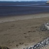
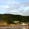
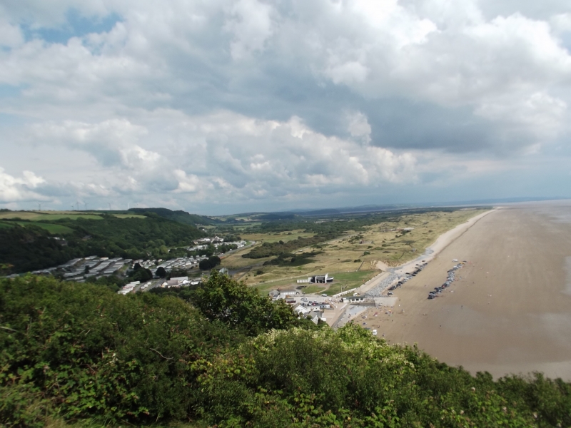
Pendine Sands is a seven-mile stretch of sandy beach situated on the shore of Carmarthen Bay in Carmarthenshire, Wales. The beach is backed by a belt of sand dunes and offers clear views across Carmarthen Bay to the Gower Peninsula and Tenby. It is located within the Carmarthen Bay and Estuary Special Area of Conservation.
The beach stretches from Gilman Point to Laugharne Sands and is situated close to the small village of Pendine, from which it gets its name. The beach is extremely flat, making it an ideal location for various activities such as car and motorbike racing, which took place here in the early 20th century. In fact, several big-name racers have completed speed records on the beach, and it continues to host some racing events.
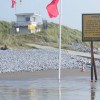
It is worth noting that Pendine Sands is owned by the Ministry of Defence (MOD) and some access is restricted to the public. The MOD run operations on the beach from Monday to Friday, and as such, the beach or part of it may be closed. The beach is split into two areas: a public section and an MOD-owned area to the east. The public area is generally open, but may close for events, while the MOD section is mostly closed on weekdays but open on weekends.
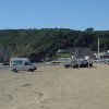
Pendine Sands is one of the few beaches in the UK where you are allowed to drive on the sand, although there are some restrictions. The beach hosts several car races and events throughout the year. Visitors can also swim, windsurf, and kite surf on the beach, which is known for its clean and clear water. The beach is surrounded by beautiful scenery, including rugged Gilman Point and sweeping views across Carmarthen Bay. There are excellent facilities nearby, including holiday parks, places to eat and drink, and easy access to the Wales Coast Path.
Bay Sand
| Today | |
|---|---|
| Chance of rain | 100% |
| Max temperature | 15°C |
| feels like | 15°C |
| Wind 24mph | |
| Max UV Index |
| Tonight | |
|---|---|
| Chance of rain | 24% |
| Min temperature | 9°C |
| feels like | 10°C |
| Wind 23mph |
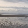
The tide at Pendine Sands is currently low. High tide will be at approximately 9:07 AM, and the next low tide will be at approximately 5:13 PM.
![]() Today's air pollution levels are forecast to be Low
Today's air pollution levels are forecast to be Low
There is is parking near the beach.
Dogs not allowed between the slipways - May to September.
Daily - 9th July - 4th September
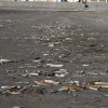
Excellent water quality
Romantic Rural West Glamorgan Stable

From £568.00 per week at Holidaycottages.co.uk
Coastal Dyfed Apartment

From £475.00 per week at Holidaycottages.co.uk
North Beach at The Hideaway

From £2806.00 per week at Sykes Holiday Cottages
Driftwood House

From £2865.00 per week at Sykes Holiday Cottages
Coastal Dyfed Apartment

From £440.00 per week at Holidaycottages.co.uk
Coastal Dyfed House
From £672.00 per week at Holidaycottages.co.uk
Morfa Bay Adventure (1 miles)
Marros Riding Centre (2.2 miles)
Laugharne Castle (4.3 miles)
The Original Tin Shed Experience (4.4 miles)
St. Martin's Church (4.5 miles)
Dylan Thomas Boathouse (4.6 miles)
All distances are approximate
less than a mile west as the seagull flies, around 3 miles by road.
around 4 miles east-northeast as the seagull flies, around 5 miles by road.
around 5 miles west as the seagull flies, around 6 miles by road.
around 6 miles west-southwest as the seagull flies, around 7 miles by road.
around 6 miles west-southwest as the seagull flies, around 9 miles by road.
around 6 miles west-southwest as the seagull flies, around 16 miles by road or 13 miles on foot using coastal paths.
around 7 miles west-southwest as the seagull flies, around 9 miles by road.
around 7 miles west-southwest as the seagull flies, around 9 miles by road.
around 7 miles east-northeast as the seagull flies, around 22 miles by road or 15 miles on foot using coastal paths.
around 7 miles west-southwest as the seagull flies, around 16 miles by road.
around 8 miles east as the seagull flies, around 31 miles by road.
around 8 miles southwest as the seagull flies, around 18 miles by road.
around 8 miles southwest as the seagull flies, around 18 miles by road.
around 8 miles southwest as the seagull flies, around 18 miles by road.
around 9 miles southwest as the seagull flies, around 20 miles by road.
around 9 miles southwest as the seagull flies, around 20 miles by road.
around 10 miles east-southeast as the seagull flies, around 36 miles by road.
around 11 miles southwest as the seagull flies, around 21 miles by road.
around 12 miles southwest as the seagull flies, around 21 miles by road.
around 13 miles west-southwest as the seagull flies, around 20 miles by road.
Location: Pentywyn (Pendine)
Location type: Village
OS Grid: SN240076
Coordinates: 51°44'22"N 4°32'59"W
Mapcode: GBR GJ.HFXF
What 3 Words: litters.shred.wicked
Coordinates and location codes are for an approximate mid-point of the beach, and may not reflect the best access point or the most popular part of the beach.
Country: Wales
Local Authority: Carmarthenshire
Parish: Pendine
Nearest postcode: SA33 4NZ
(for sat-nav purposes only, a beach does not have a postal address!)
Important! Beach information is compiled from a variety of different sources and is correct to the best of our knowledge at the time of compilation. However, information may be incorrectly supplied by our sources or go out of date after publication. BritishBeaches.uk makes no warranty as to the accuracy of any information on this page.
(Or après-beach. Or pre-beach. Or, just because you might want stuff)
Men's Tops
Weird Fish Cruiser 1/4 Zip Macaroni Sweatshirt Army Green Size 4XL

Only £45.00 from Weird Fish