Approximate Location Map
Use two fingers to pan or zoom the map
Use two fingers to pan or zoom the map
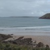
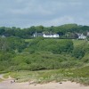
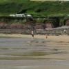
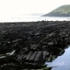
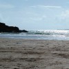
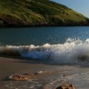
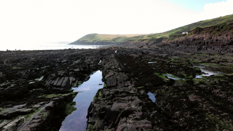
Manorbier Beach is a sandy beach, approximately 165 metres in length, surrounded by cliffs and dunes, and is situated in a picturesque village. The beach faces south east into the Atlantic and is sheltered by limestone cliffs, with the 12th century Manorbier Castle overlooking the area. A spring-fed stream flows onto the middle of the beach, where it meets the sea. The beach is popular with surfers due to a reef just offshore, and the coastal waters and coastal belt are designated as the Pembrokeshire Marine Special Area of Conservation.
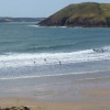
The beach offers a range of activities, including swimming, surfing, canoeing, and angling. At low tide, rock pooling is also a popular pastime. The beach is surrounded by dramatic landscapes, making it a popular spot for walkers, and a portion of the famous Pembrokeshire Coastal Path runs from Manorbier to Tenby. Visitors can also explore the 12th Century Church of St. James, the medieval Manorbier Castle, and the King’s Quoit, a Neolithic chambered tomb.
Access to the beach is via a narrow road, with parking and public toilets available nearby. However, the parking area can fill up quickly during peak season. The village of Manorbier offers a range of amenities, including a café, a local shop, and castle tours. Dogs are welcome on the beach all year round.
Visitors are advised to be cautious when swimming at Manorbier Beach, as there are strong currents and no lifeguards on duty. The beach can also get crowded in the summer, so it is recommended to arrive early if planning to participate in water sports or activities.
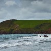
Manorbier Beach is adjacent to the Pembrokeshire Coast Path and the Wales Coast Path.
Bay Sand Rock
| Today | |
|---|---|
| Chance of rain | 91% |
| Max temperature | 16°C |
| feels like | 16°C |
| Wind 24mph | |
| Max UV Index |
| Tonight | |
|---|---|
| Chance of rain | 33% |
| Min temperature | 11°C |
| feels like | 11°C |
| Wind 24mph |
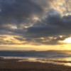
The tide at Manorbier Beach is currently falling. Low tide will be at approximately 3:07 AM, and the next high tide will be at approximately 9:40 AM.
![]() Today's air pollution levels are forecast to be Low
Today's air pollution levels are forecast to be Low
Pay-and-display car park (free out of season). About 160 places.
Dogs are allowed.
Beach cleaned daily
No lifeguard cover at this beach
![]()
![]()
Excellent water quality
Dyfed Apartment
From £656.00 per week at Holidaycottages.co.uk
Dyfed Cottage
From £720.00 per week at Holidaycottages.co.uk
The Garden Flat

From £1580.00 per week at Sykes Holiday Cottages
Luxury Coastal Dyfed House
From £679.00 per week at Holidaycottages.co.uk
Coastal Dyfed Apartment

From £546.00 per week at Holidaycottages.co.uk
Valley High

From £2198.00 per week at Sykes Holiday Cottages
Manorbier Castle (0.3 miles)
The Spa at Celtic Haven (1.7 miles)
Tenby Water Sports (2.4 miles)
Ritec Valley Quad Bikes (3.2 miles)
Lamphey Bishop's Palace (3.4 miles)
Heatherton World of Activities (3.7 miles)
Carew Castle & Tidal Mill (4 miles)
All distances are approximate
just over a mile west-northwest as the seagull flies, just over a mile by road.
just over a mile east as the seagull flies, around 2 miles by road.
around 2 miles east-northeast as the seagull flies, around 3 miles by road.
around 3 miles west as the seagull flies, around 7 miles by road or 3 miles on foot using coastal paths.
around 4 miles east-northeast as the seagull flies, around 5 miles by road.
around 4 miles east-northeast as the seagull flies, around 7 miles by road.
around 5 miles west-southwest as the seagull flies, around 9 miles by road or 7 miles on foot using coastal paths.
around 5 miles east as the seagull flies, around 5 miles by road.
around 5 miles east-northeast as the seagull flies, around 6 miles by road.
around 5 miles east-northeast as the seagull flies, around 6 miles by road.
around 6 miles west-southwest as the seagull flies, around 13 miles by road or 8 miles on foot using coastal paths.
around 6 miles northeast as the seagull flies, around 7 miles by road.
around 6 miles northeast as the seagull flies, around 9 miles by road.
around 7 miles northeast as the seagull flies, around 9 miles by road.
around 7 miles northeast as the seagull flies, around 10 miles by road.
around 7 miles northeast as the seagull flies, around 10 miles by road.
around 7 miles northwest as the seagull flies, around 12 miles by road.
around 7 miles northeast as the seagull flies, around 11 miles by road.
around 9 miles northeast as the seagull flies, around 12 miles by road.
around 11 miles west as the seagull flies, around 15 miles by road.
Location: Maenorbyr (Manorbier)
Location type: Rural
OS Grid: SS060974
Coordinates: 51°38'31"N 4°48'14"W
Mapcode: GBR GC.CDSW
What 3 Words: numeral.inflame.moss
Coordinates and location codes are for an approximate mid-point of the beach, and may not reflect the best access point or the most popular part of the beach.
Country: Wales
Local Authority: Pembrokeshire
Parish: Manorbier
Nearest postcode: SA70 7SZ
(for sat-nav purposes only, a beach does not have a postal address!)
Important! Beach information is compiled from a variety of different sources and is correct to the best of our knowledge at the time of compilation. However, information may be incorrectly supplied by our sources or go out of date after publication. BritishBeaches.uk makes no warranty as to the accuracy of any information on this page.
(Or après-beach. Or pre-beach. Or, just because you might want stuff)
Men's Tops
Weird Fish Giles Pique Polo Shirt Navy Size 2XL

Only £38.00 from Weird Fish