Approximate Location Map
Use two fingers to pan or zoom the map
Use two fingers to pan or zoom the map
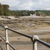
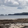
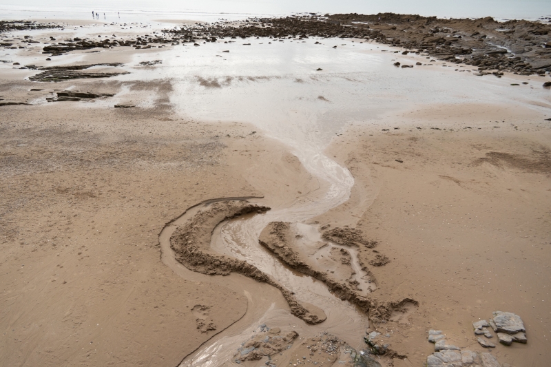
Wiseman's Bridge Beach is approximately 500 metres across and faces south east over Carmarthen Bay. The beach lies in front of a public car park and a popular pub, with several caravan and camp sites in close proximity. A small river, Fords Lake, flows into Carmarthen Bay and has a significant freshwater influence on the bathing water.
The bathing water lies within the Carmarthen Bay and Estuaries Special Area of Conservation, and the surrounding area forms part of the Saundersfoot to Telpyn Site of Special Scientific Interest. The beach is also located within Pembrokeshire Coast National Park, highlighting the environmental value of the area.
Wisemans Bridge Beach is linked to the rest of the coastline via a series of paths and tunnels, making it a popular destination for ramblers. The beach can be easily accessed on foot from Saundersfoot, and is a good choice for those looking for a quieter option than Amroth during the summer months. Visitors can walk along the National Park Coastal Footpath, which links to the main village street and continues on to the border between Pembrokeshire and Carmarthenshire.
The beach is ideal for beach games, dog walking, and rockpooling, with a wide expanse of sand at low tide and several rocky promontories to explore. Swimming is generally safe, although there is no lifeguard service. The beach is also famous for its drowned forest, and when tides are very low, visitors may be able to see blue clay and petrified tree stumps. On occasion, other ancient objects such as bones, fossils, and antlers are washed ashore.
The area played a role during World War II as a training ground for the D-Day landings, adding a layer of historical interest to your visit. The Wisemans Bridge Inn overlooks the beach, offering a convenient place to stop and refresh. The beach welcomes dogs throughout the year without any seasonal restrictions, making it a perfect spot for pet owners.
Wiseman's Bridge Beach is adjacent to the Pembrokeshire Coast Path and the Wales Coast Path.
Sand Shingle Pebbles Rock
| Today | |
|---|---|
| Chance of rain | 100% |
| Max temperature | 16°C |
| feels like | 16°C |
| Wind 23mph | |
| Max UV Index |
| Tonight | |
|---|---|
| Chance of rain | 24% |
| Min temperature | 10°C |
| feels like | 11°C |
| Wind 22mph |
The tide at Wiseman's Bridge Beach is currently rising. High tide will be at approximately 9:06 AM, and the next low tide will be at approximately 3:10 PM.
![]() Today's air pollution levels are forecast to be Low
Today's air pollution levels are forecast to be Low
Free but limited parking above the beach.
Dogs are allowed.
Hand picked daily between May and September.
No lifeguard cover at this beach
Good water quality
The Cartwheel

From £2607.00 per week at Sykes Holiday Cottages
High House (Sleeping 6)

From £566.00 per week at Rural Retreats
The Mill and Stable

From £3382.00 per week at Sykes Holiday Cottages
Pinecroft Annex

From £1423.00 per week at Sykes Holiday Cottages
Quirky Rural Dyfed Farmhouse

From £466.00 per week at Holidaycottages.co.uk
Rural Dyfed Cottage

From £505.00 per week at Holidaycottages.co.uk
Wisemans Bridge (0.2 miles)
The Reptile Experience (1 miles)
Colby Woodland Garden (National Trust) (1.5 miles)
Folly Farm (2.5 miles)
Tenby Boat Trips (3.4 miles)
Tenby Museum and Art Gallery (3.4 miles)
Tenby Lifeboat Station (3.4 miles)
Tenby Fishing (3.5 miles)
Coast Saundersfoot (310 yards)
All distances are approximate
less than a mile south-southwest as the seagull flies, just over a mile by road or less than a mile on foot using coastal paths.
less than a mile south-southwest as the seagull flies, just over a mile by road or less than a mile on foot using coastal paths.
less than a mile south-southwest as the seagull flies, around 2 miles by road.
just over a mile east-northeast as the seagull flies, around 2 miles by road.
around 2 miles south as the seagull flies, around 4 miles by road or 3 miles on foot using coastal paths.
around 3 miles south as the seagull flies, around 4 miles by road.
around 3 miles south as the seagull flies, around 5 miles by road.
around 4 miles south as the seagull flies, around 5 miles by road.
around 4 miles south-southwest as the seagull flies, around 5 miles by road.
around 5 miles south-southwest as the seagull flies, around 6 miles by road.
around 5 miles east-northeast as the seagull flies, around 6 miles by road.
around 6 miles south as the seagull flies, around 6 miles by road.
around 6 miles south-southwest as the seagull flies, around 8 miles by road.
around 6 miles east-northeast as the seagull flies, around 7 miles by road.
around 7 miles southwest as the seagull flies, around 10 miles by road.
around 7 miles southwest as the seagull flies, around 10 miles by road.
around 8 miles southwest as the seagull flies, around 13 miles by road.
around 9 miles southwest as the seagull flies, around 13 miles by road.
around 10 miles east-northeast as the seagull flies, around 12 miles by road.
around 11 miles west as the seagull flies, around 16 miles by road.
Location: Wiseman's Bridge
Location type: Town
Nearest village: Pleasant Valley
OS Grid: SN144059
Coordinates: 51°43'18"N 4°41'13"W
Mapcode: GBR GF.MMN3
What 3 Words: noses.computer.nuptials
Coordinates and location codes are for an approximate mid-point of the beach, and may not reflect the best access point or the most popular part of the beach.
Country: Wales
Local Authority: Pembrokeshire
Parish: Saundersfoot
Nearest postcode: SA69 9AX
(for sat-nav purposes only, a beach does not have a postal address!)
Important! Beach information is compiled from a variety of different sources and is correct to the best of our knowledge at the time of compilation. However, information may be incorrectly supplied by our sources or go out of date after publication. BritishBeaches.uk makes no warranty as to the accuracy of any information on this page.
(Or après-beach. Or pre-beach. Or, just because you might want stuff)
Women's Dresses & Skirts
Weird Fish Romaro Printed Jersey Midi Skirt Crimson Size 14

Only £28.00 from Weird Fish