Approximate Location Map
Use two fingers to pan or zoom the map
Use two fingers to pan or zoom the map
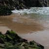
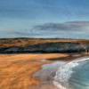
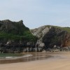
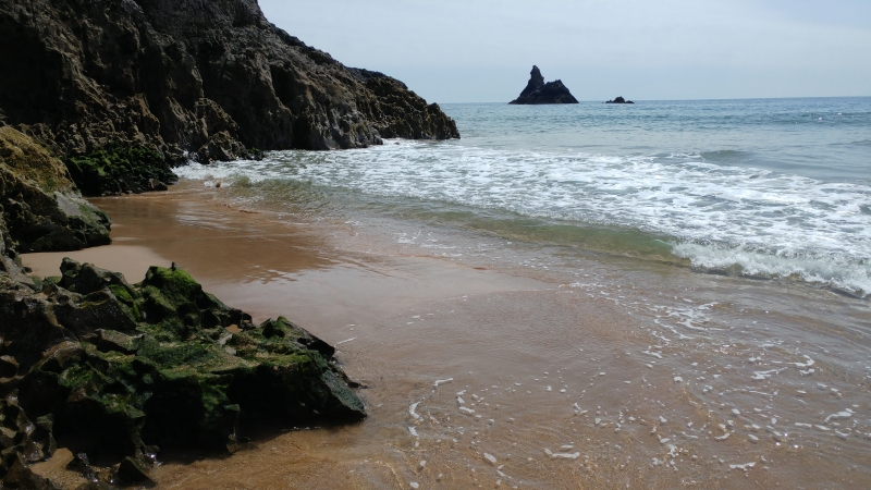
Broadhaven South Beach is one of two beaches in Pembrokeshire with this name, and it measures approximately 350 metres in length at low tide. The beach faces south-east and is backed by sand dunes, with limestone cliffs on either side. The bay forms part of the Pembrokeshire Marine Special Area of Conservation, confirming the high conservation status of the area, and the bathing water lies within Pembrokeshire Coast National Park.
The beach is a top spot for families, with a lifeguard on duty during the summer months, an ice cream kiosk, and a large car park. On a west-south-west swell, it is popular with surfers, although the nearby Newgale and Druidstone beaches are probably better suited for this type of activity. At low tide, the sands stretch for a considerable distance, making the beach feel spacious and uncrowded. However, visitors should be cautious of strong currents that can change quickly.
There are several ways to access the beach, including walking through the scenic dunes or climbing down steep steps cut into the side of one of the encircling cliffs. The beach offers plenty of opportunities for exploration, including discovering small caves and underground springs on the islands and boulders on the west side of the cove. Visitors can also search for fish and other fauna in a spring that leads through lily ponds close to the sand dunes. Further exploration of the area can lead to the Bosherton Lakes, a series of flooded valleys managed by the National Trust.
For those looking for amenities, Bosherton Village offers a range of cafes, pubs, and shops. The village is a short distance from the beach and provides a convenient base for visitors.
Broad Haven South Beach is adjacent to the Pembrokeshire Coast Path.
Sand
| Today | |
|---|---|
| Chance of rain | 90% |
| Max temperature | 16°C |
| feels like | 16°C |
| Wind 24mph | |
| Max UV Index |
| Tonight | |
|---|---|
| Chance of rain | 14% |
| Min temperature | 11°C |
| feels like | 11°C |
| Wind 23mph |
The tide at Broad Haven South Beach is currently falling. Low tide will be at approximately 3:07 AM, and the next high tide will be at approximately 9:40 AM.
![]() Today's air pollution levels are forecast to be Low
Today's air pollution levels are forecast to be Low
There is a National Trust car park - there is a fee for this unless you are a member.
Dogs are allowed.
Beach cleaned daily
Daily - 18th June - 4th September
![]()
![]()
Excellent water quality
Castle at The Hideaway

From £2960.00 per week at Sykes Holiday Cottages
3 Horse Pool Road

From £2132.00 per week at Sykes Holiday Cottages
Puffin Cottage

From £2930.00 per week at Sykes Holiday Cottages
Bwthyn Trecoed

From £1915.00 per week at Sykes Holiday Cottages
Romantic Dyfed Cottage

From £648.00 per week at Holidaycottages.co.uk
Curlew

From £3271.00 per week at Sykes Holiday Cottages
Lily Ponds (0.9 miles)
St Govan's Chapel (1 miles)
Stackpole Walled Garden (2.7 miles)
Fishing and Foraging Wales (4.1 miles)
Drew Buckley Photography (4.4 miles)
Lamphey Bishop's Palace (4.6 miles)
Pembroke Castle (4.8 miles)
All distances are approximate
just over a mile northeast as the seagull flies, around 5 miles by road or just over a mile on foot using coastal paths.
around 4 miles northeast as the seagull flies, around 8 miles by road or 5 miles on foot using coastal paths.
around 5 miles northeast as the seagull flies, around 11 miles by road or 7 miles on foot using coastal paths.
around 6 miles east-northeast as the seagull flies, around 13 miles by road or 8 miles on foot using coastal paths.
around 7 miles east-northeast as the seagull flies, around 14 miles by road or 9 miles on foot using coastal paths.
around 7 miles north as the seagull flies, around 12 miles by road.
around 7 miles west-northwest as the seagull flies, around 9 miles by road.
around 8 miles east-northeast as the seagull flies, around 15 miles by road or 11 miles on foot using coastal paths.
around 9 miles northwest as the seagull flies, around 17 miles by road.
around 9 miles east-northeast as the seagull flies, around 17 miles by road or 12 miles on foot using coastal paths.
around 10 miles west-northwest as the seagull flies, around 12 miles by road.
around 10 miles east-northeast as the seagull flies, around 17 miles by road or 13 miles on foot using coastal paths.
around 10 miles east-northeast as the seagull flies, around 17 miles by road or 12 miles on foot using coastal paths.
around 10 miles east-northeast as the seagull flies, around 17 miles by road.
around 11 miles east-northeast as the seagull flies, around 17 miles by road.
around 11 miles east-northeast as the seagull flies, around 18 miles by road.
around 11 miles northwest as the seagull flies, around 18 miles by road.
around 12 miles northwest as the seagull flies, around 21 miles by road.
around 12 miles northeast as the seagull flies, around 18 miles by road.
around 12 miles west-northwest as the seagull flies, around 27 miles by road.
Location: Bosherston
Location type: Rural
OS Grid: SR979939
Coordinates: 51°36'29"N 4°55'10"W
Mapcode: GBR G9.0L8Y
What 3 Words: haggling.joined.seaweed
Coordinates and location codes are for an approximate mid-point of the beach, and may not reflect the best access point or the most popular part of the beach.
Country: Wales
Local Authority: Pembrokeshire
Parish: Stackpole and Castlemartin
Nearest postcode: SA71 5DZ
(for sat-nav purposes only, a beach does not have a postal address!)
Important! Beach information is compiled from a variety of different sources and is correct to the best of our knowledge at the time of compilation. However, information may be incorrectly supplied by our sources or go out of date after publication. BritishBeaches.uk makes no warranty as to the accuracy of any information on this page.
(Or après-beach. Or pre-beach. Or, just because you might want stuff)
Women's Outerwear
Weird Fish Flete Lightweight Showerproof Padded Hooded Jacket Antique Moss Size L

Only £60.00 from Weird Fish