Approximate Location Map
Use two fingers to pan or zoom the map
Use two fingers to pan or zoom the map
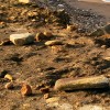
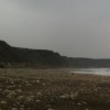
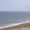
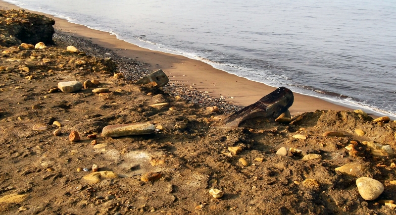
Horden Beach is part of the Durham Heritage Coast and is situated near the former mining community of Horden, approximately 12 miles south of Sunderland. The beach is composed mainly of shingle and pebble, and is backed by grasslands and cliffs. Historically, colliery waste was dumped on the beach, which had a significant impact on the environment, causing the sand to become blackened by coal-stained waste.
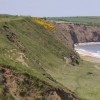
Although the beach still bears the marks of its mining heritage, the colliery waste is gradually being washed away by the sea. A lot of coal spoil was dumped on Horden beach, and this material is currently in the process of dispersing. The beach is long and backed by an extensive National Trust Area, and is bordered at its south end by the picturesque Denesmouth.
Some of the rocks on the beach have an interesting hue, being stained by iron-ore. The beach offers good walks along the beach, the cliff tops, and to the south, around Dene mouth.
Places to eat, shops, and other amenities can be found in Peterlee, which is the nearest town to the beach.
Easington Beach, a small shingle and rocky stretch on the Durham Heritage Coast, is also located in the area. This beach attracts fossil hunters, walkers, and nature lovers, and is backed by the Easington Colliery Local Nature Reserve. The nearest parking for Easington Beach is Easington Colliery Coastal Carpark.
Horden Beach is on the Durham Heritage Coast.
Sand Shingle
| Today | |
|---|---|
| Chance of rain | 85% |
| Max temperature | 15°C |
| feels like | 15°C |
| Wind 20mph | |
| Max UV Index |
| Tonight | |
|---|---|
| Chance of rain | 28% |
| Min temperature | 11°C |
| feels like | 10°C |
| Wind 17mph |
The tide at Horden Beach is currently falling. Low tide will be at approximately 12:46 PM, and the next high tide will be at approximately 6:59 PM.
![]() Today's air pollution levels are forecast to be Low
Today's air pollution levels are forecast to be Low
There is a car park just behind the beach, off the B1283.
Dogs are allowed.
No lifeguard cover at this beach
Water quality not measured here
Wellberry

From £1704.00 per week at Sykes Holiday Cottages
Beacon

From £1643.00 per week at Sykes Holiday Cottages
Holly Edge

From £2977.00 per week at Sykes Holiday Cottages
Little Nest Cottage

From £1451.00 per week at Sykes Holiday Cottages
204 Sea View House

From £2601.00 per week at Sykes Holiday Cottages
Romantic North Yorkshire Cottage
From £404.00 per week at Holidaycottages.co.uk
Ward Jackson Park (0.8 miles)
Castle Eden Dene (2.3 miles)
Little Land Play (2.9 miles)
Peterlee Parachute Centre (3.3 miles)
Tweddle Children's Animal Farm (3.3 miles)
The AFF School (3.5 miles)
Cineworld Dalton Park (3.9 miles)
Dalton Park Outlet (3.9 miles)
The Durham Fly Fishing Company (4.1 miles)
East Durham Heritage & Lifeboat Centre (4.5 miles)
All distances are approximate
less than a mile north-northwest as the seagull flies, around 2 miles by road.
just over a mile south-southeast as the seagull flies, around 3 miles by road or 2 miles on foot using coastal paths.
around 2 miles southeast as the seagull flies, around 3 miles by road.
around 4 miles southeast as the seagull flies, around 5 miles by road.
around 5 miles north-northwest as the seagull flies, around 8 miles by road or 5 miles on foot using coastal paths.
around 5 miles north-northwest as the seagull flies, around 8 miles by road or 5 miles on foot using coastal paths.
around 5 miles north-northwest as the seagull flies, around 8 miles by road or 6 miles on foot using coastal paths.
around 5 miles southeast as the seagull flies, around 6 miles by road.
around 5 miles north-northwest as the seagull flies, around 10 miles by road or 6 miles on foot using coastal paths.
around 6 miles southeast as the seagull flies, around 8 miles by road.
around 7 miles north-northwest as the seagull flies, around 9 miles by road.
around 7 miles north-northwest as the seagull flies, around 9 miles by road.
around 8 miles north-northwest as the seagull flies, around 12 miles by road.
around 8 miles south-southeast as the seagull flies, around 9 miles by road.
around 8 miles north-northwest as the seagull flies, around 11 miles by road.
around 9 miles south-southeast as the seagull flies, around 11 miles by road.
around 11 miles south-southeast as the seagull flies, around 12 miles by road.
around 11 miles north-northwest as the seagull flies, around 14 miles by road.
around 12 miles north-northwest as the seagull flies, around 15 miles by road.
around 14 miles southeast as the seagull flies, around 28 miles by road.
Location: Horden, Horden
Location type: Village
OS Grid: NZ447424
Coordinates: 54°46'28"N 1°18'19"W
Mapcode: GBR MFB7.57
What 3 Words: rips.myself.firmly
Coordinates and location codes are for an approximate mid-point of the beach, and may not reflect the best access point or the most popular part of the beach.
Country: England
Local Authority: County Durham
Parish: Horden
Nearest postcode: SR8 4TL
(for sat-nav purposes only, a beach does not have a postal address!)
Important! Beach information is compiled from a variety of different sources and is correct to the best of our knowledge at the time of compilation. However, information may be incorrectly supplied by our sources or go out of date after publication. BritishBeaches.uk makes no warranty as to the accuracy of any information on this page.
(Or après-beach. Or pre-beach. Or, just because you might want stuff)
Men's Tops
Weird Fish Beye 1/4 Zip Grid Fleece Ecru Size 12

Only £45.00 from Weird Fish