Approximate Location Map
Use two fingers to pan or zoom the map
Use two fingers to pan or zoom the map
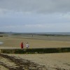
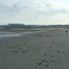
Minnis Bay is a long sandy bay backed by grassland, farmland, and cliffs, making it a safe and popular destination for families. The beach offers a range of activities, including sailing, windsurfing, paddling, kayaking, and beach games. There is a sailing club and a zoned area for boats, windsurfers, and kite boarders.
The beach has a wide range of amenities, including free car parking, toilets, a children's play area, a picnic area, a kiosk for ice creams, and a cafe on the promenade. There are also opportunities for kite boarding lessons, seal watching trips, cycling routes, and coastal walks. Visitors can enjoy swimming, sunbathing, and ball games on the beach, and there is a paddling pool for youngsters. The beach is patrolled by RNLI Lifeguards during the summer.
Minnis Bay is located east of the Thames Estuary, facing the North Sea midway between Herne Bay and Margate. The area is served by an open-top bus in summer, and visitors can also bring bicycles and ride along the Viking Coastal Trail to Margate. The beach is almost flat and bordered by sand dunes, making it ideal for walking and sunbathing.
There are several options for food and drink at Minnis Bay, including the Minnis Bay Bar & Brasserie, which offers meals overlooking the seafront, and the Windshack Cafe, which serves snacks further along the beach.
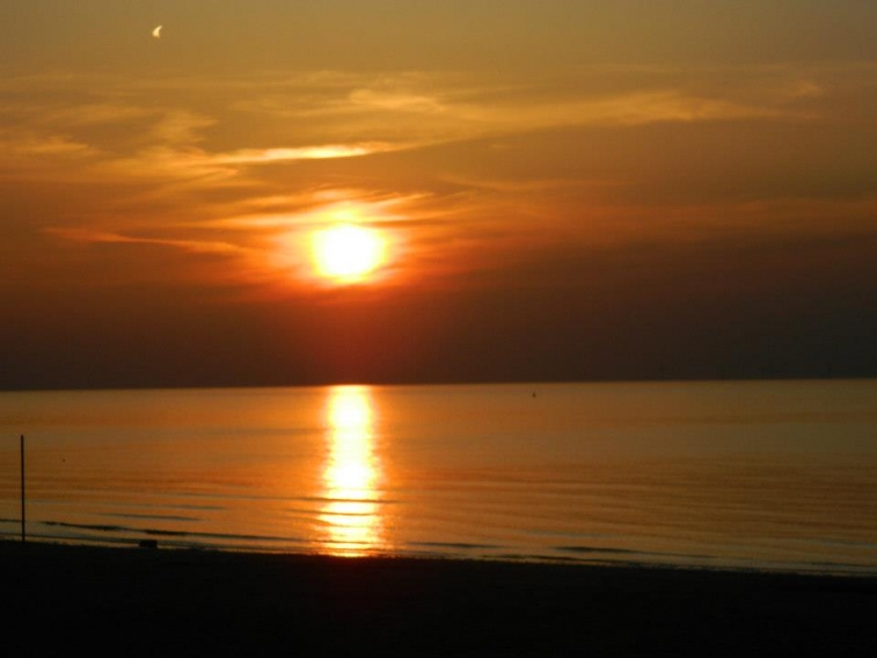
Dogs are banned from the beach in summer, and beach wheelchairs are available for visitors with mobility needs. The beach has been listed as one of Britain's best beaches, and it is a great place to watch the sun set into the sea.
Minnis Bay is adjacent to the Kent Coastline Walk and the Viking Coastal Trail.
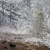
Bay Sand Rock
| Today | |
|---|---|
| Chance of rain | 79% |
| Max temperature | 17°C |
| feels like | 18°C |
| Wind 24mph | |
| Max UV Index |
| Tonight | |
|---|---|
| Chance of rain | 57% |
| Min temperature | 12°C |
| feels like | 13°C |
| Wind 18mph |
The tide at Minnis Bay is currently rising. High tide will be at approximately 3:17 PM, and the next low tide will be at approximately 9:36 PM.
![]() Today's air pollution levels are forecast to be Low
Today's air pollution levels are forecast to be Low
There is parking for around 100 cars including disabled spaces - a charge applies. Off-street parking is also available.
Dogs not allowed May 1st to 30th September at any time.
Beach cleaned daily during the summer and weekly the rest of the year.
Daily - 9th July - 4th September
Weekends - 21st May - 3rd July
![]()
Excellent water quality
Echo Beach

From £2072.00 per week at Sykes Holiday Cottages
Kent Cottage
From £936.00 per week at Holidaycottages.co.uk
Whitstable Bay Getaway

From £2120.00 per week at Sykes Holiday Cottages
Kent Cottage
From £803.00 per week at Holidaycottages.co.uk
Coastal Kent Cottage

From £1209.00 per week at Holidaycottages.co.uk
Kent Cottage
From £750.00 per week at Holidaycottages.co.uk
Quex Park and The Powell-Cotton Museum (1.6 miles)
Carlton Cinema (2.3 miles)
The RAF Manston History Museum (3.5 miles)
Spitfire & Hurricane Memorial Museum (3.5 miles)
Reculver Towers and Roman Fort (4 miles)
Margate Museum (4.3 miles)
CTRL ALT ESC Technology Based Escape Rooms (4.6 miles)
The Escapement - Margate Escape Rooms (4.7 miles)
Sandwich and Pegwell Bay National Nature Reserve (5.1 miles)
All distances are approximate
around 2 miles east as the seagull flies, around 2 miles by road.
around 3 miles east as the seagull flies, around 3 miles by road.
around 3 miles east as the seagull flies, around 4 miles by road.
around 3 miles west as the seagull flies, around 8 miles by road or 4 miles on foot using coastal paths.
around 4 miles east as the seagull flies, around 5 miles by road.
around 5 miles east-northeast as the seagull flies, around 5 miles by road.
around 5 miles east as the seagull flies, around 6 miles by road.
around 6 miles east as the seagull flies, around 6 miles by road.
around 6 miles west as the seagull flies, around 10 miles by road or 6 miles on foot using coastal paths.
around 6 miles west as the seagull flies, around 10 miles by road or 7 miles on foot using coastal paths.
around 6 miles southeast as the seagull flies, around 8 miles by road.
around 7 miles east as the seagull flies, around 8 miles by road.
around 7 miles east-southeast as the seagull flies, around 9 miles by road.
around 7 miles east as the seagull flies, around 8 miles by road.
around 7 miles east as the seagull flies, around 9 miles by road.
around 7 miles east-southeast as the seagull flies, around 8 miles by road.
around 7 miles west as the seagull flies, around 11 miles by road or 8 miles on foot using coastal paths.
around 8 miles west as the seagull flies, around 11 miles by road or 8 miles on foot using coastal paths.
around 8 miles south-southeast as the seagull flies, around 13 miles by road.
around 10 miles west as the seagull flies, around 14 miles by road.
Location: Birchington, Margate
Location type: Urban
OS Grid: TR286696
Coordinates: 51°22'48"N 1°17'2"E
Mapcode: GBR VYJ.FGD
What 3 Words: hotels.rollover.copes
Coordinates and location codes are for an approximate mid-point of the beach, and may not reflect the best access point or the most popular part of the beach.
County: Kent
Country: England
Local Authority: Thanet
Parish: Birchington
Nearest postcode: CT7 9QR
(for sat-nav purposes only, a beach does not have a postal address!)
Important! Beach information is compiled from a variety of different sources and is correct to the best of our knowledge at the time of compilation. However, information may be incorrectly supplied by our sources or go out of date after publication. BritishBeaches.uk makes no warranty as to the accuracy of any information on this page.
(Or après-beach. Or pre-beach. Or, just because you might want stuff)
Men's Tops
Weird Fish Explorer Front Print Graphic T-Shirt Navy Size 3XL

Only £28.00 from Weird Fish