Approximate Location Map
Use two fingers to pan or zoom the map
Use two fingers to pan or zoom the map
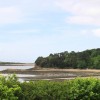
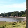
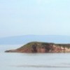
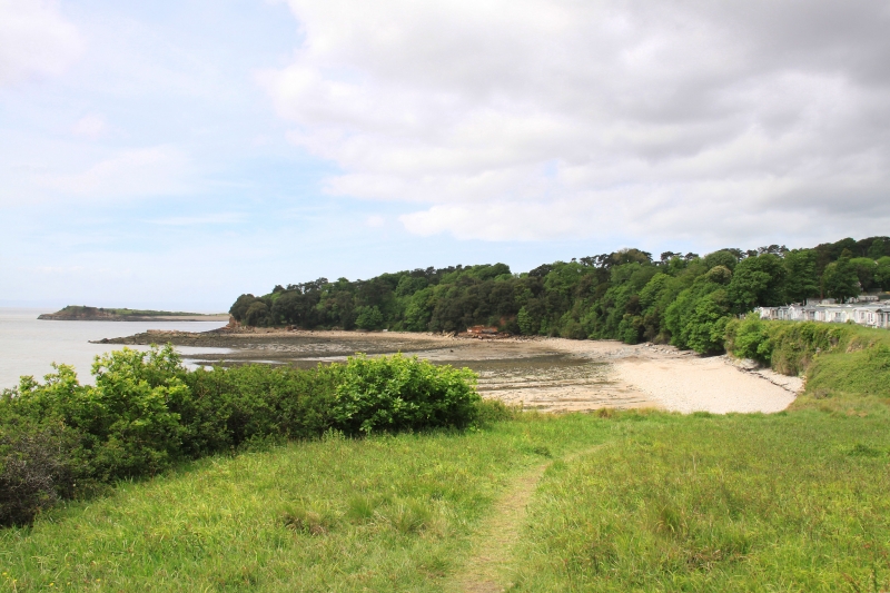
St. Marys Well Bay is a small sand and rock beach situated close to Cardiff, looking out over the Bristol Channel. The bay is nestled between Sully Island and Lavernock Point, and its terrain is a mixture of sand, pebbles, and rocks. At low tide, a large area of mud and wet sand is exposed, featuring seaweed-covered stones. The beach offers views over the Bristol Channel towards Avon and Somerset, as well as Flat Holm, a limestone island and the most southern point in Wales. Steep Holm, the island behind it, is technically located in England.
Lavernock Point, also known as Trwyn Larnog in Welsh, is a significant headland located in Glamorgan, Wales. It marks the point where the Severn estuary becomes the Bristol Channel and offers views towards Flat Holm Island. The area is notable for its interesting geological formations, featuring coastal cliffs composed of sedimentary rocks from the late Triassic and early Jurassic periods. These formations include the Blue Lias and Lavernock Shales, which are rich in fossils of oysters and other marine life. A notable discovery was made in 2015, when a dinosaur fossil named Dracoraptor hanigan was found in the area.
Lavernock Point holds historical importance as the site of the first successful wireless message transmitted over open sea by Guglielmo Marconi in 1897. This achievement marked a significant moment in communication history, connecting Lavernock Point to Flat Holm Island. A plaque commemorating this event is located nearby, and visitors can also stop by the Marconi Inn, a local pub.
Visitors to St. Marys Well Bay should be aware that there are no facilities such as restrooms, cafes, or shops available. However, a charming St Lawrence Church is located close to the car park and is well worth a visit. It is also recommended to exercise caution when approaching the rocky cliffs behind the eastern end of the beach, as they can be unstable.
St. Marys Well Bay is adjacent to the Wales Coast Path.
Sand Rock
| Today | |
|---|---|
| Chance of rain | 100% |
| Max temperature | 16°C |
| feels like | 16°C |
| Wind 22mph | |
| Max UV Index |
| Tonight | |
|---|---|
| Chance of rain | 51% |
| Min temperature | 10°C |
| feels like | 11°C |
| Wind 21mph |
The tide at St. Marys Well Bay is currently high. Low tide will be at approximately 4:01 PM, and the next high tide will be at approximately 10:14 PM.
![]() Today's air pollution levels are forecast to be Low
Today's air pollution levels are forecast to be Low
Lavernock Car Park is near the beach.
Dogs are allowed
No lifeguard cover at this beach
Water quality not measured here
3 The Stables

From £2121.00 per week at Sykes Holiday Cottages
Luxury Rural Somerset Barn

From £530.00 per week at Holidaycottages.co.uk
Ash Lodge

From £2823.00 per week at Sykes Holiday Cottages
3 Old Police Station

From £2247.00 per week at Sykes Holiday Cottages
Luxury Romantic Burrington Stable Barn

From £386.00 per week at Holidaycottages.co.uk
Fig Trees - Wibble Farm

From £1229.00 per week at Sykes Holiday Cottages
Cosmeston Lakes Country Park (1 miles)
Glass By Design (2.3 miles)
Penarth Pier Pavilion (2.4 miles)
Cardiff International White Water (3.3 miles)
Cardiff Bay Barrage (3.5 miles)
Brit Movie Tours (4 miles)
Barry Island Pleasure Park (4.1 miles)
Smugglers Cove (4.2 miles)
High Street (4.2 miles)
All distances are approximate
around 2 miles north-northeast as the seagull flies, around 3 miles by road.
around 3 miles west as the seagull flies, around 4 miles by road.
around 4 miles west as the seagull flies, around 7 miles by road.
around 4 miles west-southwest as the seagull flies, around 7 miles by road.
around 4 miles west-southwest as the seagull flies, around 6 miles by road.
around 5 miles west-southwest as the seagull flies, around 7 miles by road.
around 5 miles west as the seagull flies, around 7 miles by road.
around 8 miles west as the seagull flies, around 12 miles by road.
around 9 miles east-southeast as the seagull flies, around 62 miles by road.
around 9 miles east-southeast as the seagull flies, around 61 miles by road.
around 10 miles east-southeast as the seagull flies, around 61 miles by road.
around 10 miles east as the seagull flies, around 60 miles by road.
around 10 miles east-southeast as the seagull flies, around 62 miles by road.
around 10 miles east-southeast as the seagull flies, around 63 miles by road.
around 10 miles west as the seagull flies, around 13 miles by road.
around 10 miles southeast as the seagull flies, around 68 miles by road.
around 11 miles southeast as the seagull flies, around 72 miles by road.
around 12 miles southeast as the seagull flies, around 71 miles by road.
around 14 miles east as the seagull flies, around 52 miles by road.
around 14 miles southeast as the seagull flies, around 68 miles by road.
Location: Swanbridge,
Location type: Rural
OS Grid: ST179676
Coordinates: 51°24'7"N 3°10'52"W
Mapcode: GBR HY.QSLV
What 3 Words: prestige.unloads.snowboard
Coordinates and location codes are for an approximate mid-point of the beach, and may not reflect the best access point or the most popular part of the beach.
Country: Wales
Local Authority: Vale of Glamorgan
Parish: Sully and Lavernock
Nearest postcode: CF6 2XS
(for sat-nav purposes only, a beach does not have a postal address!)
Important! Beach information is compiled from a variety of different sources and is correct to the best of our knowledge at the time of compilation. However, information may be incorrectly supplied by our sources or go out of date after publication. BritishBeaches.uk makes no warranty as to the accuracy of any information on this page.
(Or après-beach. Or pre-beach. Or, just because you might want stuff)
Women's Trousers
Weird Fish Nalani Printed Viscose Jumpsuit Azure Size 20

Only £42.00 from Weird Fish