Approximate Location Map
Use two fingers to pan or zoom the map
Use two fingers to pan or zoom the map
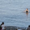
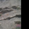
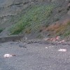
Penarth Beach is a long expanse of beach interspersed with groynes and a large pier, which is a popular spot for fishing. The beach is mostly pebbles, but towards the sea it becomes increasingly sandy, with plenty of exposed sand at low tide. However, due to the proximity of various river estuaries, there are strong currents and the water is often a murky brown with silt.
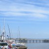
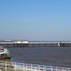
The beach is backed by an esplanade, along which there are parking spaces, some restaurants, toilets, and an attractive-looking pier. The pier underwent a multi-million pound restoration project in recent years and is now home to a small cinema theatre and thriving cafe. Visitors can enjoy swimming, walking, and searching for fossils along the beach. The pier is also a popular place for fishing.
The beach is accessed via either stairs or a slipway. Penarth railway station is about 500 meters from the pier, through Alexandra Gardens. The town centre, with plenty of shops and places to eat and drink, is a little further along the road.
It's essential to check tide times before heading out onto the beach, as the tidal range is significant and the incoming tide can quickly cover large areas of sand. Dogs are banned from Penarth Beach during the summer months, specifically from May 1 to September 30. However, outside of this period, you can bring your furry friends to enjoy the beach.
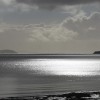
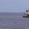
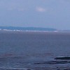
From the beach, there are views across the Bristol Channel towards Weston-super-Mare. The islands of Steep Holm and Flat Holm are visible from the beach. If you head south down the seafront, you will get to where the dinosaur footprints are located. Details and a location map are available for free from Penarth's RNLI shop.
Sand Rock
| Today | |
|---|---|
| Chance of rain | 100% |
| Max temperature | 16°C |
| feels like | 16°C |
| Wind 22mph | |
| Max UV Index |
| Tonight | |
|---|---|
| Chance of rain | 51% |
| Min temperature | 10°C |
| feels like | 11°C |
| Wind 21mph |
The tide at Penarth Beach is currently high. Low tide will be at approximately 4:03 PM, and the next high tide will be at approximately 10:13 PM.
![]() Today's air pollution levels are forecast to be Low
Today's air pollution levels are forecast to be Low
Limited parking at Lavernock Point, in summer parking available at St Mary's Well Bay. In winter roadside parking only.
No dogs between May and September.
No lifeguard cover at this beach
Water quality not measured here
Romantic Rustic Devauden Cottage

From £878.00 per week at Holidaycottages.co.uk
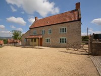
Romantic Rural Somerset House

From £421.00 per week at Holidaycottages.co.uk
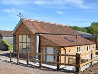
Heritage Retreat

From £3061.00 per week at Sykes Holiday Cottages
Rural Somerset Farm Cottage
From £618.00 per week at Holidaycottages.co.uk
Somerset Cottage

From £359.00 per week at Holidaycottages.co.uk
Rural Somerset House
From £875.00 per week at Holidaycottages.co.uk
Penarth Pier Pavilion (0.3 miles)
Glass By Design (0.4 miles)
Cosmeston Lakes Country Park (1.2 miles)
Cardiff Bay Barrage (1.4 miles)
Cardiff International White Water (1.4 miles)
The Open Boat (2.2 miles)
Bay Island Voyages (2.2 miles)
Breakout Cardiff (3.3 miles)
Lab 22 (3.3 miles)
Cardiff On Foot (3.4 miles)
All distances are approximate
around 2 miles south-southwest as the seagull flies, around 2 miles by road.
around 4 miles southwest as the seagull flies, around 5 miles by road.
around 5 miles southwest as the seagull flies, around 8 miles by road.
around 5 miles west-southwest as the seagull flies, around 8 miles by road.
around 6 miles west-southwest as the seagull flies, around 7 miles by road.
around 6 miles west-southwest as the seagull flies, around 8 miles by road.
around 6 miles west-southwest as the seagull flies, around 8 miles by road.
around 9 miles west-southwest as the seagull flies, around 13 miles by road.
around 10 miles southeast as the seagull flies, around 60 miles by road.
around 10 miles east-southeast as the seagull flies, around 58 miles by road.
around 10 miles southeast as the seagull flies, around 59 miles by road.
around 10 miles southeast as the seagull flies, around 59 miles by road.
around 10 miles southeast as the seagull flies, around 60 miles by road.
around 11 miles southeast as the seagull flies, around 61 miles by road.
around 11 miles west-southwest as the seagull flies, around 14 miles by road.
around 11 miles southeast as the seagull flies, around 65 miles by road.
around 12 miles southeast as the seagull flies, around 70 miles by road.
around 13 miles east as the seagull flies, around 50 miles by road.
around 13 miles south-southeast as the seagull flies, around 69 miles by road.
around 13 miles east as the seagull flies, around 50 miles by road.
Location: Penarth
Location type: Urban
OS Grid: ST188708
Coordinates: 51°25'51"N 3°10'8"W
Mapcode: GBR HY.P3L0
What 3 Words: tidy.pound.dates
Coordinates and location codes are for an approximate mid-point of the beach, and may not reflect the best access point or the most popular part of the beach.
Country: Wales
Local Authority: Vale of Glamorgan
Parish: Penarth
Nearest postcode: CF6 2BA
(for sat-nav purposes only, a beach does not have a postal address!)
Important! Beach information is compiled from a variety of different sources and is correct to the best of our knowledge at the time of compilation. However, information may be incorrectly supplied by our sources or go out of date after publication. BritishBeaches.uk makes no warranty as to the accuracy of any information on this page.
(Or après-beach. Or pre-beach. Or, just because you might want stuff)
Men's Tops
Weird Fish Miles Pique Polo Shirt Navy Size XL

Only £38.00 from Weird Fish