Approximate Location Map
Use two fingers to pan or zoom the map
Use two fingers to pan or zoom the map
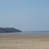
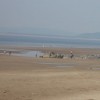
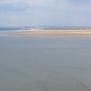
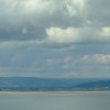
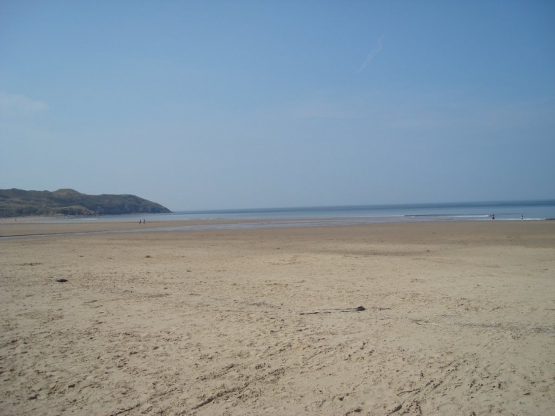
Broughton Bay is a popular spot for surfers and beachgoers alike, with its large expanse of sandy beach backed by dunes. The bay's sands are constantly shifting, and beachcombers have made several interesting discoveries, including the handle of a 17th-century sword. The area is also of historical significance, with evidence of Palaeolithic and Roman occupation in the caves around the cliffs at the northern end of the bay.
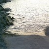
However, the beach is not suitable for swimming and can be hazardous for watersport enthusiasts due to strong currents from the Loughor Estuary, fast-incoming tides, and shifting sands. There is no lifeguard on duty and no facilities available, making it a tranquil but undeveloped spot.
Access to the beach can be tricky, but a small car park is located about 400 metres from the beach. The bay is flanked by clusters of caravan parks at either end. Visitors are advised to be sure-footed when accessing the beach.
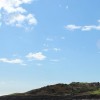
The beach and surrounding area are rich in biodiversity, with rolling sand dunes, salt marshes, and rock pools to explore at low tide. The bay is a popular spot for surfing, and its west-facing position makes it ideal for watching sunsets. The area is also great for photographers, birdwatchers, and nature enthusiasts.
Visitors are advised to bring all necessary supplies, including water, snacks, and sun protection, as there are no shops or toilets on the beach. The beach is open to dogs all year round, with no seasonal restrictions, making it a great spot for those with pets. Overall, Broughton Bay is a wild and natural spot, perfect for those looking to escape into nature and enjoy the unspoiled Gower coast.
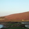
Broughton Bay is adjacent to the Gower Coast Path and the Wales Coast Path.
Sand
| Today | |
|---|---|
| Chance of rain | 100% |
| Max temperature | 15°C |
| feels like | 15°C |
| Wind 25mph | |
| Max UV Index |
| Tonight | |
|---|---|
| Chance of rain | 41% |
| Min temperature | 10°C |
| feels like | 11°C |
| Wind 24mph |
The tide at Broughton Bay is currently rising. High tide will be at approximately 9:20 AM, and the next low tide will be at approximately 3:34 PM.
![]() Today's air pollution levels are forecast to be Low
Today's air pollution levels are forecast to be Low
Parking available a short walk from the beach
Dogs are allowed: http://www.swansea.gov.uk/dogsonbeaches
No lifeguard cover at this beach
Water quality not measured here
Sandpiper Cottage

From £2729.00 per week at Sykes Holiday Cottages
Coastal Dyfed House
From £399.00 per week at Holidaycottages.co.uk
The Woodlands Lower Level

From £7717.00 per week at Sykes Holiday Cottages
Dyfed Cottage

From £543.00 per week at Holidaycottages.co.uk
Rustic Rural Dyfed Cottage
From £360.00 per week at Holidaycottages.co.uk
Rural Dyfed Cottage
From £463.00 per week at Holidaycottages.co.uk
WSF: Welsh Surfing Federation Surf School (1.6 miles)
Rhossili Bay (3.2 miles)
National Trust Rhossili Shop & Visitor Centre (3.3 miles)
Board Riding Development Mountain Boarding Centre (3.6 miles)
Worm's Head (3.7 miles)
Weobley Castle (3.8 miles)
Gower Coast Adventures (4.2 miles)
Pembrey Country Park (4.3 miles)
All distances are approximate
around 2 miles south-southwest as the seagull flies, around 2 miles by road.
around 3 miles south as the seagull flies, around 11 miles by road or 4 miles on foot using coastal paths.
around 4 miles south as the seagull flies, around 11 miles by road or 5 miles on foot using coastal paths.
around 4 miles south as the seagull flies, around 10 miles by road or 5 miles on foot using coastal paths.
around 4 miles north-northeast as the seagull flies, around 24 miles by road.
around 5 miles north-northwest as the seagull flies, around 30 miles by road.
around 6 miles southeast as the seagull flies, around 8 miles by road.
around 6 miles northeast as the seagull flies, around 20 miles by road.
around 7 miles southeast as the seagull flies, around 9 miles by road.
around 7 miles east-southeast as the seagull flies, around 9 miles by road.
around 8 miles east-southeast as the seagull flies, around 10 miles by road.
around 10 miles north-northwest as the seagull flies, around 31 miles by road.
around 10 miles east-southeast as the seagull flies, around 16 miles by road or 13 miles on foot using coastal paths.
around 11 miles east-southeast as the seagull flies, around 16 miles by road or 13 miles on foot using coastal paths.
around 11 miles east-southeast as the seagull flies, around 17 miles by road.
around 11 miles north-northwest as the seagull flies, around 47 miles by road.
around 12 miles east-southeast as the seagull flies, around 17 miles by road.
around 12 miles east as the seagull flies, around 17 miles by road.
around 13 miles east as the seagull flies, around 17 miles by road.
around 13 miles east as the seagull flies, around 18 miles by road.
Location: Cwm Ivy
Location type: Rural
Nearest village: Llangennith
OS Grid: SS420933
Coordinates: 51°36'58"N 4°16'57"W
Mapcode: GBR GQ.K0FQ
What 3 Words: silk.resolves.javelin
Coordinates and location codes are for an approximate mid-point of the beach, and may not reflect the best access point or the most popular part of the beach.
Country: Wales
Local Authority: Swansea
Parish: Llangennith, Llanmadoc and Cheriton
Nearest postcode: SA3 1JN
(for sat-nav purposes only, a beach does not have a postal address!)
Important! Beach information is compiled from a variety of different sources and is correct to the best of our knowledge at the time of compilation. However, information may be incorrectly supplied by our sources or go out of date after publication. BritishBeaches.uk makes no warranty as to the accuracy of any information on this page.
(Or après-beach. Or pre-beach. Or, just because you might want stuff)
Men's Tops
Weird Fish Beye 1/4 Zip Grid Fleece Grass Green Size 8

Only £18.00 from Weird Fish