Approximate Location Map
Use two fingers to pan or zoom the map
Use two fingers to pan or zoom the map
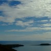
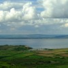
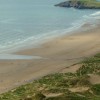
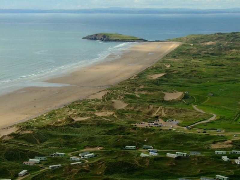
Rhossili North Beach is part of a wide expanse of sand stretching 3 kilometres from Burry Holmes to Worms Head. The gently sloping bay faces west out into the Atlantic and is backed by steep limestone cliffs on the south side, Rhossili Downs on the east, with sand dunes and moors in the north. The beach offers visitors a three-mile stretch of clean, golden sands backed by dunes and dominated by the stunning Rhossili Downs.
The beach is a popular spot for walkers, with scenic walking trails, including routes to Blue Pool and the natural archway called Three Chimneys. Visitors can also explore the nearby archaeological sites, including the remains of an Iron Age fort and a World War II radar station. The wreck of the Helveti, a cargo ship which sank in 1887, can be seen on the beach. For surfers, Llangennith Sands Beach, located at the northern end of Rhossili Bay, is a hotspot with fantastic waves, and surf schools are nearby.
The Worms Head promontory, a tidal island, is accessible at low tide via a rock causeway, but walkers should be aware of the incoming tide rising quickly and potentially trapping them. The promontory is one of the most photographed landmarks in Wales and offers spectacular views.
The Rhossili Downs above the beach are popular with walkers and hang gliders, providing magnificent views over the coastline and out to sea. A popular camping and caravan site is located at Hillend, 200 metres from the beach.
Rhossili Beach was voted Best Beach in Britain in 2010 and Wales's Best Beach in 2017.
Bay Sand
| Today | |
|---|---|
| Chance of rain | 100% |
| Max temperature | 15°C |
| feels like | 15°C |
| Wind 25mph | |
| Max UV Index |
| Tonight | |
|---|---|
| Chance of rain | 30% |
| Min temperature | 10°C |
| feels like | 11°C |
| Wind 24mph |
The tide at Rhossili North Beach is currently falling. Low tide will be at approximately 3:34 PM, and the next high tide will be at approximately 9:38 PM.
![]() Today's air pollution levels are forecast to be Low
Today's air pollution levels are forecast to be Low
There is a car park next to the beach - a charge applies.
Dogs are allowed: http://www.swansea.gov.uk/dogsonbeaches
No lifeguard cover at this beach
![]()
Excellent water quality
The Woodlands Lower Level

From £7717.00 per week at Sykes Holiday Cottages
Coastal Dyfed Apartment
From £713.00 per week at Holidaycottages.co.uk
Flat 56 Newton Road

From £1831.00 per week at Sykes Holiday Cottages
South Beach at The Hideaway

From £2420.00 per week at Sykes Holiday Cottages
Romantic Rural Dyfed Glamping

From £555.00 per week at Holidaycottages.co.uk
Coastal Dyfed Apartment

From £662.00 per week at Holidaycottages.co.uk
WSF: Welsh Surfing Federation Surf School (0.3 miles)
Rhossili Bay (1.4 miles)
National Trust Rhossili Shop & Visitor Centre (1.6 miles)
Worm's Head (1.9 miles)
Gower Coast Adventures (2.5 miles)
Board Riding Development Mountain Boarding Centre (4.4 miles)
Weobley Castle (4.6 miles)
Gower Peninsula (5.5 miles)
All distances are approximate
just over a mile south as the seagull flies, around 10 miles by road or 2 miles on foot using coastal paths.
around 2 miles north-northeast as the seagull flies, around 2 miles by road.
around 2 miles south as the seagull flies, around 10 miles by road or 4 miles on foot using coastal paths.
around 2 miles south-southeast as the seagull flies, around 10 miles by road or 3 miles on foot using coastal paths.
around 5 miles southeast as the seagull flies, around 8 miles by road.
around 6 miles north-northwest as the seagull flies, around 30 miles by road.
around 6 miles north-northeast as the seagull flies, around 24 miles by road.
around 6 miles east-southeast as the seagull flies, around 9 miles by road.
around 7 miles east-southeast as the seagull flies, around 9 miles by road.
around 8 miles northeast as the seagull flies, around 20 miles by road.
around 8 miles east as the seagull flies, around 10 miles by road.
around 11 miles east as the seagull flies, around 16 miles by road.
around 11 miles north-northwest as the seagull flies, around 31 miles by road.
around 11 miles east as the seagull flies, around 16 miles by road.
around 11 miles east as the seagull flies, around 17 miles by road.
around 12 miles east as the seagull flies, around 17 miles by road.
around 13 miles north-northwest as the seagull flies, around 47 miles by road.
around 13 miles east as the seagull flies, around 17 miles by road.
around 13 miles east as the seagull flies, around 18 miles by road.
around 13 miles east as the seagull flies, around 17 miles by road.
Location: Llangennith
Location type: Village
OS Grid: SS410905
Coordinates: 51°35'29"N 4°17'46"W
Mapcode: GBR GQ.3NTF
What 3 Words: polished.gamer.subplot
Coordinates and location codes are for an approximate mid-point of the beach, and may not reflect the best access point or the most popular part of the beach.
Country: Wales
Local Authority: Swansea
Parish: Llangennith, Llanmadoc and Cheriton
Nearest postcode: SA3 1JH
(for sat-nav purposes only, a beach does not have a postal address!)
Important! Beach information is compiled from a variety of different sources and is correct to the best of our knowledge at the time of compilation. However, information may be incorrectly supplied by our sources or go out of date after publication. BritishBeaches.uk makes no warranty as to the accuracy of any information on this page.
(Or après-beach. Or pre-beach. Or, just because you might want stuff)
Men's Tops
Weird Fish Beye 1/4 Zip Grid Fleece Purple Wine Size 12

Only £45.00 from Weird Fish