Approximate Location Map
Use two fingers to pan or zoom the map
Use two fingers to pan or zoom the map
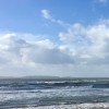
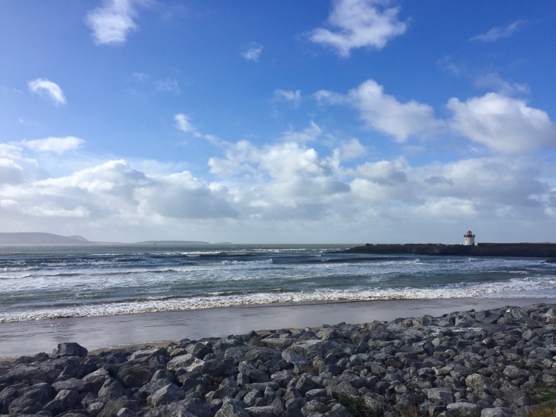
Burry Port Beach is a long, mostly sandy beach with some pebbles to the east of the marina. The beach is backed by sand dunes, and a long coastal path takes visitors to Llanelli, which lies east of the beach. The area is popular for watersports such as boating from the marina, which has its own lighthouse. Walkers also enjoy the surroundings, although there are warning signs about the dangers of walking on the sandbanks and also about swimming in the area.
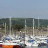
The marina at Burry Port is a small, attractive harbour favoured by small yachts and fishing vessels with a high tidal range. Big boats can only access the port at high tide. The marina has a local yacht club, pub, and shops. Parking, for which there is a small charge, can be found around the marina, as well as facilities such as toilets, cafes, and a harbour office. More facilities can be found in the town centre of Burry Port, a few hundred meters away, including a range of shops and a railway station.
The lighthouse at Burry Port divides the beach into east and west. Burry Port West is quiet and unspoilt, backed by a holiday park. From this part of the beach, you can walk along to the historic Pembrey Harbour. Burry Port East has the RNLI lifeboat station and plenty of parking. Here, you can walk along the beach and take the Millennium Coastal path.
The former coal mining town of Burry Port is now popular with golf enthusiasts and walkers, with Pembrey Burrows, a wetland ecosystem, and Pembrey Country Park to the west of the marina. While swimming is permitted, it's advisable to check local conditions and be cautious, as there are no lifeguard services on the beach.
Burry Port Beach is adjacent to the Wales Coast Path.
Harbour Estuary
| Today | |
|---|---|
| Chance of rain | 100% |
| Max temperature | 16°C |
| feels like | 16°C |
| Wind 25mph | |
| Max UV Index |
| Tonight | |
|---|---|
| Chance of rain | 56% |
| Min temperature | 10°C |
| feels like | 11°C |
| Wind 23mph |
The tide at Burry Port Beach is currently rising. High tide will be at approximately 9:20 AM, and the next low tide will be at approximately 3:34 PM.
![]() Today's air pollution levels are forecast to be Low
Today's air pollution levels are forecast to be Low
There is parking by the beach - a charge applies.
Dogs are allowed.
No lifeguard cover at this beach
![]()
Water quality not measured here
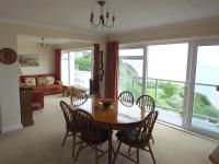
North Beach at The Hideaway

From £2806.00 per week at Sykes Holiday Cottages
Dyfed Cottage

From £636.00 per week at Holidaycottages.co.uk
Castle School House

From £2313.00 per week at Sykes Holiday Cottages
Gwyddno Lodge

From £3152.00 per week at Sykes Holiday Cottages
Llety'r Llwynog

From £2636.00 per week at Sykes Holiday Cottages
Coastal Dyfed Apartment
From £669.00 per week at Holidaycottages.co.uk
Ashburnham Golf Club (0.8 miles)
Pembrey Country Park (2.4 miles)
Stradey Castle (2.9 miles)
Millennium Coastal Park (3 miles)
Llanelly House (3.7 miles)
The Escape Game Llanelli (3.8 miles)
Parc Howard Museum and Art Gallery (3.9 miles)
The Ffwrnes (3.9 miles)
Odeon Cinema (3.9 miles)
All distances are approximate
around 3 miles east as the seagull flies, around 5 miles by road or 4 miles on foot using coastal paths.
around 4 miles west as the seagull flies, around 5 miles by road.
around 4 miles south-southwest as the seagull flies, around 24 miles by road.
around 6 miles south-southwest as the seagull flies, around 24 miles by road.
around 7 miles northwest as the seagull flies, around 9 miles by road.
around 8 miles south-southwest as the seagull flies, around 28 miles by road.
around 8 miles south-southwest as the seagull flies, around 28 miles by road.
around 8 miles south as the seagull flies, around 27 miles by road.
around 9 miles northwest as the seagull flies, around 23 miles by road.
around 9 miles southeast as the seagull flies, around 21 miles by road.
around 9 miles south-southeast as the seagull flies, around 24 miles by road.
around 9 miles southeast as the seagull flies, around 20 miles by road.
around 9 miles south-southeast as the seagull flies, around 26 miles by road.
around 11 miles northwest as the seagull flies, around 27 miles by road.
around 11 miles southeast as the seagull flies, around 20 miles by road.
around 12 miles southeast as the seagull flies, around 20 miles by road.
around 12 miles southeast as the seagull flies, around 21 miles by road.
around 12 miles east-southeast as the seagull flies, around 18 miles by road.
around 12 miles east-southeast as the seagull flies, around 18 miles by road.
around 13 miles east-southeast as the seagull flies, around 17 miles by road.
Location: Porth Tywyn (Burry Port)
Location type: Town
OS Grid: SN446000
Coordinates: 51°40'39"N 4°14'53"W
Mapcode: GBR GQ.X9H4
What 3 Words: shining.stay.megawatt
Coordinates and location codes are for an approximate mid-point of the beach, and may not reflect the best access point or the most popular part of the beach.
Country: Wales
Local Authority: Carmarthenshire
Parish: Pembrey and Burry Port Town
Nearest postcode: SA16 0LT
(for sat-nav purposes only, a beach does not have a postal address!)
Important! Beach information is compiled from a variety of different sources and is correct to the best of our knowledge at the time of compilation. However, information may be incorrectly supplied by our sources or go out of date after publication. BritishBeaches.uk makes no warranty as to the accuracy of any information on this page.
(Or après-beach. Or pre-beach. Or, just because you might want stuff)
Men's Tops
Weird Fish Beye 1/4 Zip Grid Fleece Ecru Size 12

Only £45.00 from Weird Fish