Approximate Location Map
Use two fingers to pan or zoom the map
Use two fingers to pan or zoom the map
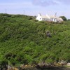
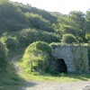
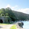
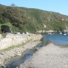
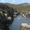
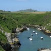
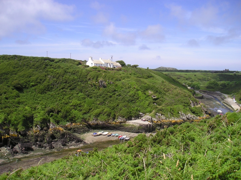
Porth Clais Beach is a narrow, enclosed bay that forms a small natural harbour at the mouth of the River Alun. The beach is submerged at high tide, but at low tide, a good-sized patch of sand is revealed behind the breakwater. The bay is flanked by rocky slopes, densely packed with gorse bushes, and features a sea wall and a couple of disused lime kilns, remnants of a trading history that dates back to Roman times.
The harbour has a rich history, with limestone, grain, timber, and other goods once being traded here. Today, the area is popular with kayakers and rock climbers, and the Pembrokeshire Coast Path runs immediately above both sides of the harbour. The picturesque area is rich in birdlife, and in spring and early summer, there is an abundance of wildflowers.
The River Alun, which flows into the harbour, was once rich in eels, and in springtime, tiny glassy elvers could be seen swimming into the sea here on their long journey to the distant Sargasso Sea. Visitors to the area can enjoy kayaking, rock climbing, and walking along the Pembrokeshire Coast Path.
There is a National Trust car park close to the beach, with toilets and a small café. Charges may apply for parking. A seafront kiosk is also open in the holidays, selling refreshments.
Porth Clais Beach is adjacent to the Pembrokeshire Coast Path and the Wales Coast Path.
Harbour
| Today | |
|---|---|
| Chance of rain | 100% |
| Max temperature | 14°C |
| feels like | 14°C |
| Wind 23mph | |
| Max UV Index |
| Tonight | |
|---|---|
| Chance of rain | % |
| Min temperature | 11°C |
| feels like | 11°C |
| Wind 24mph |
The tide at Porth Clais Beach is currently falling. Low tide will be at approximately 3:47 AM, and the next high tide will be at approximately 9:47 AM.
![]() Today's air pollution levels are forecast to be Low
Today's air pollution levels are forecast to be Low
Parking is close-by
Dogs allowed.
No lifeguard cover at this beach
Water quality not measured here
Ty Cerrig

From £3035.00 per week at Sykes Holiday Cottages
Luxury Coastal Dyfed Farmhouse
From £1517.00 per week at Holidaycottages.co.uk
Granston Cottage

From £2213.00 per week at Sykes Holiday Cottages
Bwthyn Alarch

From £2247.00 per week at Sykes Holiday Cottages
The Shepherd Hut

From £823.00 per week at Sykes Holiday Cottages
Dolphin

From £1892.00 per week at Sykes Holiday Cottages
St. Davids Cathedral (1.1 miles)
Ramsey Island Boat Trips -Thousand Islands Expeditions (1.1 miles)
TYF Adventure - Day Adventures (1.1 miles)
Voyages of Discovery (Ramsey Island) (1.1 miles)
Falcon Boats (1.1 miles)
Dragon Activity Guides (1.4 miles)
Venture Jet (1.5 miles)
The Real Adventure Company (1.8 miles)
Whitesands Bay (2 miles)
Dr Beynon's Bug Farm (2.3 miles)
All distances are approximate
just over a mile east-northeast as the seagull flies, around 2 miles by road.
around 2 miles northwest as the seagull flies, around 3 miles by road or 2 miles on foot using coastal paths.
around 2 miles north-northwest as the seagull flies, around 3 miles by road.
around 6 miles north-northeast as the seagull flies, around 6 miles by road.
around 6 miles north-northeast as the seagull flies, around 7 miles by road.
around 6 miles north-northeast as the seagull flies, around 7 miles by road.
around 7 miles east as the seagull flies, around 9 miles by road.
around 8 miles east-southeast as the seagull flies, around 13 miles by road.
around 9 miles east-southeast as the seagull flies, around 14 miles by road.
around 9 miles south-southeast as the seagull flies, around 27 miles by road or 20 miles on foot using coastal paths.
around 9 miles northeast as the seagull flies, around 10 miles by road.
around 9 miles south as the seagull flies, around 30 miles by road or 24 miles on foot using coastal paths.
around 10 miles southeast as the seagull flies, around 16 miles by road.
around 10 miles southeast as the seagull flies, around 17 miles by road.
around 11 miles south-southeast as the seagull flies, around 29 miles by road or 23 miles on foot using coastal paths.
around 11 miles northeast as the seagull flies, around 15 miles by road.
around 12 miles south-southeast as the seagull flies, around 29 miles by road or 23 miles on foot using coastal paths.
around 12 miles south-southeast as the seagull flies, around 29 miles by road or 22 miles on foot using coastal paths.
around 12 miles south-southeast as the seagull flies, around 27 miles by road or 21 miles on foot using coastal paths.
around 13 miles southeast as the seagull flies, around 28 miles by road or 20 miles on foot using coastal paths.
Location: Tyddewi (St Davids)
Location type: Town
OS Grid: SM743238
Coordinates: 51°52'4"N 5°16'46"W
Mapcode: GBR C5.SF3Z
What 3 Words: drawn.trooper.lyricist
Coordinates and location codes are for an approximate mid-point of the beach, and may not reflect the best access point or the most popular part of the beach.
Country: Wales
Local Authority: Pembrokeshire
Parish: St. David's and the Cathedral Close
Nearest postcode: SA62 6RR
(for sat-nav purposes only, a beach does not have a postal address!)
Important! Beach information is compiled from a variety of different sources and is correct to the best of our knowledge at the time of compilation. However, information may be incorrectly supplied by our sources or go out of date after publication. BritishBeaches.uk makes no warranty as to the accuracy of any information on this page.
(Or après-beach. Or pre-beach. Or, just because you might want stuff)
Women's Outerwear
Weird Fish Gleason Faux Shearling Jacket Putty Size 16

Only £48.00 from Weird Fish