Approximate Location Map
Use two fingers to pan or zoom the map
Use two fingers to pan or zoom the map
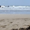
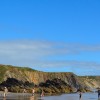
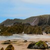
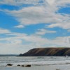
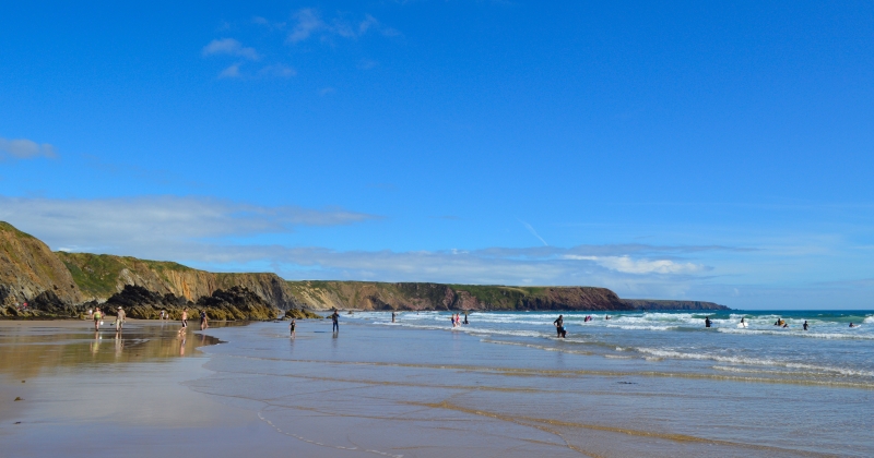
Marloes Sands is a large expanse of sandy beach, measuring approximately 2 kilometres in length, situated within the National Park. The beach is notable for its cliffs with strange rock formations and is backed by steep limestone cliffs. The beach faces south east into the Bristol Channel, towards Stockholm island. The surrounding land is predominantly agricultural, with the small town of Marloes located 1.3 kilometres north west of the bay.
The coastal waters and coastal belt form part of the Pembrokeshire Marine Special Area of Conservation and is also designated as Special Site of Scientific Interest, confirming the high conservation status of the area. The bathing water also lies within Pembrokeshire Coast National Park.
Stretching over a mile, this expanse of golden sand offers some of the most spectacular scenery anywhere on the Welsh coast. The beach is exposed to the full force of the ocean, combined with the high cliffs that back the beach, making it a very dramatic location. This location has been used for filming, including scenes from the 2011 film “Snow White and the Huntsman” and the 1968 historical drama “The Lion in Winter”. At low tide, Marloes Sands becomes a continuous expanse of sand punctuated by rocky outcrops. However, it is worth keeping an eye on the tide times as the beach can all but disappear on the high tide.
The area is home to a wealth of wildlife, including seals and a variety of bird life. The nearby islands of Skomer and Skokholm are home to colonies of puffin, shearwaters, petrels, razorbills and other seabirds. The beach also features interesting geology, with layered sandstone and shale rock formations.
There is a National Trust car park half a mile from the beach and the nearest facilities are in the village of Marloes, which is also close to Martins Haven, from where boat trips can be taken to Skomer and Skokholm. The Pembrokeshire Coast Path winds along the clifftops above the beach.
Sand
| Today | |
|---|---|
| Chance of rain | 99% |
| Max temperature | 15°C |
| feels like | 15°C |
| Wind 24mph | |
| Max UV Index |
| Tonight | |
|---|---|
| Chance of rain | % |
| Min temperature | 12°C |
| feels like | 12°C |
| Wind 24mph |
The tide at Marloes Sands is currently low. High tide will be at approximately 9:27 AM, and the next low tide will be at approximately 3:42 PM.
![]() Today's air pollution levels are forecast to be Low
Today's air pollution levels are forecast to be Low
Parking is available for over 30 cars and there is a charge.
Dogs are allowed.
Beach cleaned daily
No lifeguard cover at this beach
![]()
![]()
Excellent water quality
Hideaway

From £1282.00 per week at Sykes Holiday Cottages
Ty Landsker

From £8081.00 per week at Sykes Holiday Cottages
Copybush Cottage

From £7066.00 per week at Sykes Holiday Cottages
Pant y FFynnon

From £1997.00 per week at Sykes Holiday Cottages
Rural Dyfed Barn

From £567.00 per week at Holidaycottages.co.uk
The Long Barn

From £2613.00 per week at Sykes Holiday Cottages
Awesome Fishing (1 miles)
Pembrokeshire Islands Boat Trips (1.7 miles)
Skomer Island (3.6 miles)
West Angle Bay (5.1 miles)
Chapel Bay Fort & Museum (5.3 miles)
Blue lagoon abereiddy (5.9 miles)
All distances are approximate
just over a mile southeast as the seagull flies, around 5 miles by road or 2 miles on foot using coastal paths.
around 2 miles northwest as the seagull flies, around 2 miles by road.
around 2 miles east-southeast as the seagull flies, around 4 miles by road or 3 miles on foot using coastal paths.
around 3 miles north-northeast as the seagull flies, around 4 miles by road or 3 miles on foot using coastal paths.
around 3 miles southeast as the seagull flies, around 5 miles by road or 4 miles on foot using coastal paths.
around 4 miles east as the seagull flies, around 4 miles by road.
around 5 miles east as the seagull flies, around 8 miles by road or 6 miles on foot using coastal paths.
around 5 miles east-southeast as the seagull flies, around 30 miles by road.
around 6 miles northeast as the seagull flies, around 7 miles by road.
around 6 miles northeast as the seagull flies, around 7 miles by road.
around 7 miles east as the seagull flies, around 10 miles by road.
around 8 miles northeast as the seagull flies, around 10 miles by road.
around 8 miles southeast as the seagull flies, around 28 miles by road.
around 8 miles north-northeast as the seagull flies, around 11 miles by road.
around 10 miles north-northeast as the seagull flies, around 20 miles by road or 14 miles on foot using coastal paths.
around 11 miles north-northwest as the seagull flies, around 29 miles by road or 23 miles on foot using coastal paths.
around 11 miles north as the seagull flies, around 28 miles by road or 21 miles on foot using coastal paths.
around 12 miles east as the seagull flies, around 16 miles by road.
around 12 miles north-northwest as the seagull flies, around 29 miles by road or 23 miles on foot using coastal paths.
around 13 miles north-northwest as the seagull flies, around 30 miles by road or 24 miles on foot using coastal paths.
Location: Marloes
Location type: Rural
OS Grid: SM782074
Coordinates: 51°43'17"N 5°12'44"W
Mapcode: GBR G2.HM1K
What 3 Words: witty.worldwide.detriment
Coordinates and location codes are for an approximate mid-point of the beach, and may not reflect the best access point or the most popular part of the beach.
Country: Wales
Local Authority: Pembrokeshire
Parish: Marloes and St. Brides
Nearest postcode: SA62 3BH
(for sat-nav purposes only, a beach does not have a postal address!)
Important! Beach information is compiled from a variety of different sources and is correct to the best of our knowledge at the time of compilation. However, information may be incorrectly supplied by our sources or go out of date after publication. BritishBeaches.uk makes no warranty as to the accuracy of any information on this page.
(Or après-beach. Or pre-beach. Or, just because you might want stuff)
Men's Tops
Weird Fish Lyon Organic Cotton Colour Block Rugby Shirt Garnet Size S

Only £35.00 from Weird Fish