Approximate Location Map
Use two fingers to pan or zoom the map
Use two fingers to pan or zoom the map
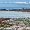
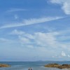
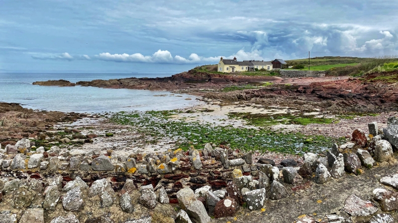
St Brides Haven is a shingle and pebble beach situated in a cove, facing north-west and sheltered from the prevailing wind. The beach is set in a pretty inlet, protected from the worst of the winds, and offers a safe and enjoyable environment for families.
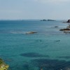
The beach is a good spot for families, with shallow waters close to the shore making it ideal for children to paddle. A small stream runs into the sea, and there are plenty of rock pools dotted around the beach, perfect for exploring and spotting sea life. Basic facilities are available, and small boats can be launched from the beach. The surrounding waters offer good fishing opportunities.
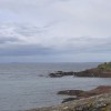
The northern side of the beach features a clutch of cottages, and it is believed that a chapel for fishermen once stood there, which tumbled into the sea many years ago. As the cliffs have crumbled, stone coffins have been exposed, dating back to the 6th-10th century. Nearby, visitors can find St Brides (or Kensington) Castle, which dates back to 1833 and was once the home of the Barons of Kensington. The castle now provides self-catering accommodation.
The beach is surrounded by rugged cliffs and hills, providing a stunning backdrop for visitors. The coastal path runs along the edge of the bay, offering spectacular views of the surrounding landscape. Another charming and secluded cove, St Brides Bay, is also located nearby.
St. Brides Haven Beach is adjacent to the Pembrokeshire Coast Path and the Wales Coast Path.
Shingle Pebbles
| Today | |
|---|---|
| Chance of rain | 99% |
| Max temperature | 15°C |
| feels like | 15°C |
| Wind 24mph | |
| Max UV Index |
| Tonight | |
|---|---|
| Chance of rain | % |
| Min temperature | 12°C |
| feels like | 12°C |
| Wind 24mph |
The tide at St. Brides Haven Beach is currently rising. High tide will be at approximately 9:27 AM, and the next low tide will be at approximately 3:42 PM.
![]() Today's air pollution levels are forecast to be Low
Today's air pollution levels are forecast to be Low
Free parking for 20 cars near the beach.
Dogs are allowed.
Beach manually cleaned daily by the council.
No lifeguard cover at this beach
Water quality not measured here
Derlwyn

From £2342.00 per week at Sykes Holiday Cottages
Maerdy Cwtch

From £2387.00 per week at Sykes Holiday Cottages
Middle Cottage

From £2342.00 per week at Sykes Holiday Cottages
Romantic Coastal Dyfed Cottage

From £687.00 per week at Holidaycottages.co.uk
Zoar Chapel

From £2583.00 per week at Sykes Holiday Cottages
Coastal Dyfed Cottage

From £859.00 per week at Holidaycottages.co.uk
Awesome Fishing (1.7 miles)
Pembrokeshire Islands Boat Trips (2.8 miles)
Blue lagoon abereiddy (3.7 miles)
Skomer Island (4.9 miles)
Chapel Bay Fort & Museum (5.8 miles)
West Angle Bay (5.8 miles)
Nolton Stables (6 miles)
All distances are approximate
around 3 miles south-southwest as the seagull flies, around 4 miles by road or 3 miles on foot using coastal paths.
around 3 miles west-southwest as the seagull flies, around 6 miles by road or 4 miles on foot using coastal paths.
around 3 miles south as the seagull flies, around 5 miles by road.
around 3 miles south-southeast as the seagull flies, around 4 miles by road.
around 4 miles east-northeast as the seagull flies, around 5 miles by road.
around 4 miles southeast as the seagull flies, around 4 miles by road.
around 4 miles east-northeast as the seagull flies, around 5 miles by road.
around 4 miles east-southeast as the seagull flies, around 7 miles by road.
around 4 miles south-southeast as the seagull flies, around 6 miles by road.
around 5 miles northeast as the seagull flies, around 8 miles by road.
around 6 miles southeast as the seagull flies, around 28 miles by road.
around 6 miles northeast as the seagull flies, around 9 miles by road.
around 6 miles east-southeast as the seagull flies, around 8 miles by road.
around 8 miles north-northeast as the seagull flies, around 18 miles by road or 11 miles on foot using coastal paths.
around 9 miles southeast as the seagull flies, around 26 miles by road.
around 9 miles north-northwest as the seagull flies, around 26 miles by road or 18 miles on foot using coastal paths.
around 9 miles north-northwest as the seagull flies, around 27 miles by road or 20 miles on foot using coastal paths.
around 10 miles north-northwest as the seagull flies, around 27 miles by road or 20 miles on foot using coastal paths.
around 11 miles north-northwest as the seagull flies, around 28 miles by road or 20 miles on foot using coastal paths.
around 11 miles east-southeast as the seagull flies, around 14 miles by road.
Location: Marloes
Location type: Rural
OS Grid: SM801109
Coordinates: 51°45'14"N 5°11'10"W
Mapcode: GBR G2.XMWY
What 3 Words: result.squirts.attaching
Coordinates and location codes are for an approximate mid-point of the beach, and may not reflect the best access point or the most popular part of the beach.
Country: Wales
Local Authority: Pembrokeshire
Parish: Marloes and St. Brides
Nearest postcode: SA62 3AJ
(for sat-nav purposes only, a beach does not have a postal address!)
Important! Beach information is compiled from a variety of different sources and is correct to the best of our knowledge at the time of compilation. However, information may be incorrectly supplied by our sources or go out of date after publication. BritishBeaches.uk makes no warranty as to the accuracy of any information on this page.
(Or après-beach. Or pre-beach. Or, just because you might want stuff)
Women's Trousers
Weird Fish Farida Wide Leg Trouser Navy Size 12

Only £48.75 from Weird Fish