Approximate Location Map
Use two fingers to pan or zoom the map
Use two fingers to pan or zoom the map
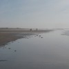
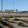
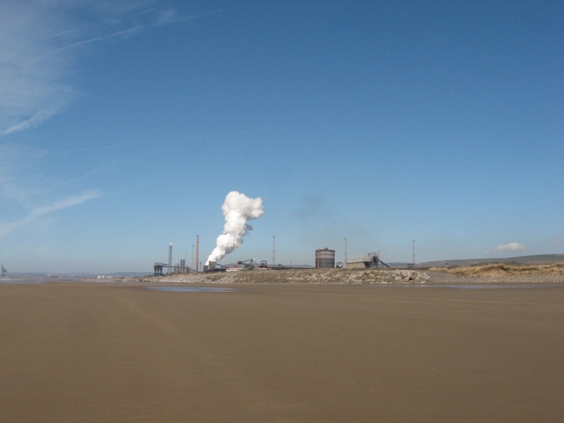
Aberafan Margam Sands is a long sandy beach situated to the south of Port Talbot. The beach is overlooked by a large steel works at its northern end, but as you move south, the surroundings transition to moorland, dunes, and the Kenfig Nature Reserve.
The beach presents a study in contrasts, with industrial influences in the north giving way to a more pristine natural landscape in the south. The southern section of the beach borders ecologically significant areas with diverse coastal wildlife, including rabbits, shorebirds, and foxes. The beach serves as an important feeding ground for wading birds, particularly during winter months.
Margam Sands experiences dramatic tidal variations, with the beach expanding significantly at low tide and reducing considerably at high tide. Visitors should check local tide tables before visiting. Unlike some nearby beaches, Margam Sands offers minimal facilities, with no permanent toilets, cafes, or lifeguard services. Visitors should come prepared with water, snacks, and other necessities.
The beach remains relatively quiet, even during peak summer periods, and is dog-friendly throughout the year. The wide open spaces make it perfect for energetic dogs, though owners should keep pets under control near sensitive dune areas and wildlife habitats. Limited designated parking areas are available, with the main access point located off Harbour Way. Alternative access is available via the Wales Coastal Path.
Harbour Sand
| Today | |
|---|---|
| Chance of rain | 100% |
| Max temperature | 15°C |
| feels like | 15°C |
| Wind 19mph | |
| Max UV Index |
| Tonight | |
|---|---|
| Chance of rain | 58% |
| Min temperature | 10°C |
| feels like | 11°C |
| Wind 18mph |
The tide at Aberafan Margam Sands is currently falling. Low tide will be at approximately 3:12 PM, and the next high tide will be at approximately 9:38 PM.
![]() Today's air pollution levels are forecast to be Low
Today's air pollution levels are forecast to be Low
Parking available towards the southern end of the beach.
There are seasonal restrictions at Aberavon: https://www.npt.gov.uk/PDF/DogExclusionZone.pdf
No information available
Water quality not measured here
Heritage Retreat

From £3061.00 per week at Sykes Holiday Cottages
No 1 Church Cottages

From £1361.00 per week at Sykes Holiday Cottages
Rural West Glamorgan Cottage

From £526.00 per week at Holidaycottages.co.uk
Rural West Glamorgan Cottage

From £530.00 per week at Holidaycottages.co.uk
Romantic Rustic Powys Cottage

From £602.00 per week at Holidaycottages.co.uk
Lothlorien Cottage

From £1250.00 per week at Sykes Holiday Cottages
Margam Park (1.9 miles)
Go Ape (2.1 miles)
The Margam Ghost Walk (2.2 miles)
Kenfig National Nature Reserve (2.9 miles)
Baked Bean Museum of Excellence (3.7 miles)
Adventures Activity Centre (4.5 miles)
Porthcawl Surf School (4.7 miles)
Porthcawl Museum (5.6 miles)
All distances are approximate
around 4 miles north-northwest as the seagull flies, around 7 miles by road.
around 4 miles northwest as the seagull flies, around 7 miles by road.
around 4 miles south-southeast as the seagull flies, around 8 miles by road or 6 miles on foot using coastal paths.
around 6 miles southeast as the seagull flies, around 10 miles by road or 8 miles on foot using coastal paths.
around 6 miles northwest as the seagull flies, around 10 miles by road.
around 6 miles southeast as the seagull flies, around 11 miles by road or 9 miles on foot using coastal paths.
around 6 miles southeast as the seagull flies, around 11 miles by road or 9 miles on foot using coastal paths.
around 6 miles northwest as the seagull flies, around 11 miles by road.
around 7 miles northwest as the seagull flies, around 11 miles by road.
around 8 miles southeast as the seagull flies, around 15 miles by road.
around 8 miles southeast as the seagull flies, around 16 miles by road.
around 8 miles west-northwest as the seagull flies, around 15 miles by road.
around 9 miles west-northwest as the seagull flies, around 14 miles by road.
around 9 miles west as the seagull flies, around 19 miles by road.
around 9 miles west as the seagull flies, around 19 miles by road.
around 9 miles west as the seagull flies, around 19 miles by road.
around 9 miles west as the seagull flies, around 19 miles by road.
around 10 miles west-northwest as the seagull flies, around 16 miles by road.
around 10 miles west-northwest as the seagull flies, around 18 miles by road.
around 10 miles west-northwest as the seagull flies, around 17 miles by road.
Location: Cwrt-y-defaid
Location type: Village
Nearest village: Eglwys Nunydd
OS Grid: SS771846
Coordinates: 51°32'48"N 3°46'22"W
Mapcode: GBR H4.FMPX
What 3 Words: growth.jeering.genius
Coordinates and location codes are for an approximate mid-point of the beach, and may not reflect the best access point or the most popular part of the beach.
Country: Wales
Local Authority: Neath Port Talbot
Parish: Margam Moors
Nearest postcode: SA13 2NT
(for sat-nav purposes only, a beach does not have a postal address!)
Important! Beach information is compiled from a variety of different sources and is correct to the best of our knowledge at the time of compilation. However, information may be incorrectly supplied by our sources or go out of date after publication. BritishBeaches.uk makes no warranty as to the accuracy of any information on this page.
(Or après-beach. Or pre-beach. Or, just because you might want stuff)
Women's Tops
Weird Fish Lucetta Lenzing EcoVero™ Printed Viscose Blouse Black Iris Size 10

Only £26.60 from Weird Fish