Approximate Location Map
Use two fingers to pan or zoom the map
Use two fingers to pan or zoom the map
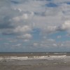
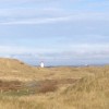
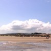
The Point of Ayr is a sand-dune point overlooking a large expanse of sand at the mouth of the Dee Estuary. This area of sand dunes, overlooking a large expanse of sand, is to be found on the western side of the River Dee Estuary. The dunes here form part of an RSPB nature reserve, which is popular with bird watchers, especially during the winter months. These dunes also provide a habitat for a rare breed of natterjack toad and the site has been designated a Site of Special Scientific Interest.
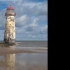
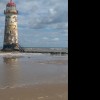
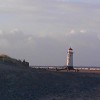
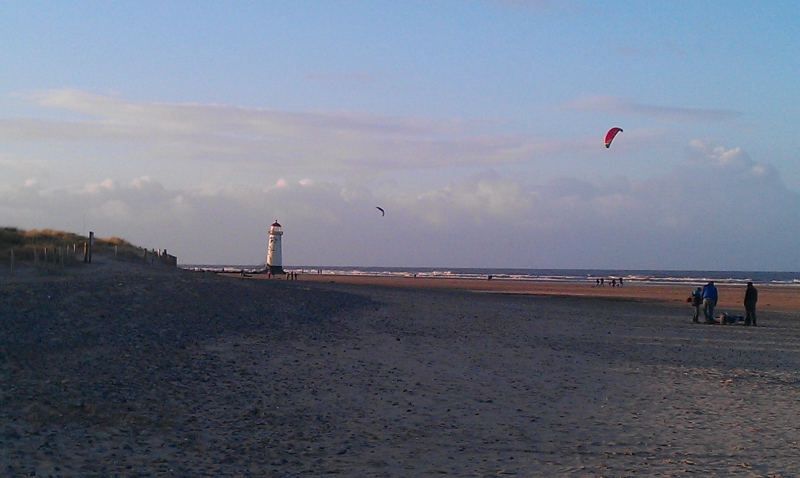
Set mid-beach, the Point of Ayr lighthouse, built in 1776 and now redundant, provides a good photo opportunity. The closest car park to the beach is at the north-eastern end of Station Road. There are a number of caravan parks in the immediate vicinity. The Wales Coast Path runs through this part of the coast and other activities on the beach include horse riding, fishing, sailing, and windsurfing.
The dunes, covered in marram grass and brimming with wildlife, are recognised as an area of Special Scientific Interest and home to a significant population of natterjack toads. The RSPB reserve is a great location for bird lovers throughout the year who visit to observe sea birds including oyster catchers and the rare Arctic Tern.
There are holiday parks in the area, traditional amusements and arcades popular with families, as well as local B&B’s. The nearest town is Prestatyn, just to the west, with holiday attractions and accommodation. This beach is dog friendly all year round. At low tide, walkers can reach the lighthouse, get a closer look, and perhaps catch a glimpse of the old lighthouse keeper.
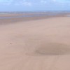
Sand
| Today | |
|---|---|
| Chance of rain | 90% |
| Max temperature | 16°C |
| feels like | 16°C |
| Wind 21mph | |
| Max UV Index |
| Tonight | |
|---|---|
| Chance of rain | 71% |
| Min temperature | 11°C |
| feels like | 12°C |
| Wind 20mph |
The tide at Point of Ayr Beach is currently rising. High tide will be at approximately 1:44 AM, and the next low tide will be at approximately 8:39 AM.
![]() Today's air pollution levels are forecast to be Low
Today's air pollution levels are forecast to be Low
There is a car park at the beach, off Station Road.
Dogs are allowed
No lifeguard cover at this beach
Water quality not measured here
Caravan 96

From £1184.00 per week at Sykes Holiday Cottages
Bethania Chapel Annex

From £1524.00 per week at Sykes Holiday Cottages
The Nook

From £1382.00 per week at Sykes Holiday Cottages
Rivendell

From £1729.00 per week at Sykes Holiday Cottages
Dove Cottage

From £1819.00 per week at Sykes Holiday Cottages
Cornel Clyd

From £2109.00 per week at Sykes Holiday Cottages
Prestatyn Shopping Park (3.6 miles)
Prestatyn High Street (3.7 miles)
Scala Cinema Prestatyn (3.7 miles)
Dyserth Waterfall (5.5 miles)
All distances are approximate
around 2 miles west-southwest as the seagull flies, around 4 miles by road or 2 miles on foot using coastal paths.
around 3 miles west-southwest as the seagull flies, around 4 miles by road.
around 4 miles west-southwest as the seagull flies, around 5 miles by road.
around 5 miles west-southwest as the seagull flies, around 6 miles by road.
around 5 miles east-northeast as the seagull flies, around 39 miles by road.
around 6 miles east as the seagull flies, around 33 miles by road.
around 6 miles west-southwest as the seagull flies, around 7 miles by road.
around 7 miles east as the seagull flies, around 31 miles by road.
around 7 miles west-southwest as the seagull flies, around 8 miles by road.
around 8 miles east-northeast as the seagull flies, around 37 miles by road.
around 9 miles west-southwest as the seagull flies, around 11 miles by road.
around 9 miles east-northeast as the seagull flies, around 36 miles by road.
around 10 miles west-southwest as the seagull flies, around 14 miles by road or 11 miles on foot using coastal paths.
around 11 miles east-northeast as the seagull flies, around 36 miles by road.
around 12 miles west-southwest as the seagull flies, around 15 miles by road.
around 12 miles east-northeast as the seagull flies, around 36 miles by road.
around 13 miles east-northeast as the seagull flies, around 38 miles by road.
around 14 miles west-southwest as the seagull flies, around 18 miles by road.
around 16 miles west-southwest as the seagull flies, around 21 miles by road.
around 17 miles west-southwest as the seagull flies, around 20 miles by road.
Location: Talacre
Location type: Village
OS Grid: SJ120853
Coordinates: 53°21'28"N 3°19'21"W
Mapcode: GBR 5Y7M.F0
What 3 Words: squashes.cape.trip
Coordinates and location codes are for an approximate mid-point of the beach, and may not reflect the best access point or the most popular part of the beach.
Country: Wales
Local Authority: Flintshire
Parish: Llanasa
Nearest postcode: CH8 9RS
(for sat-nav purposes only, a beach does not have a postal address!)
Important! Beach information is compiled from a variety of different sources and is correct to the best of our knowledge at the time of compilation. However, information may be incorrectly supplied by our sources or go out of date after publication. BritishBeaches.uk makes no warranty as to the accuracy of any information on this page.
(Or après-beach. Or pre-beach. Or, just because you might want stuff)
Women's Outerwear
Weird Fish Eshka Lightweight Padded Jacket Aubergine Size 12

Only £60.00 from Weird Fish