Approximate Location Map
Use two fingers to pan or zoom the map
Use two fingers to pan or zoom the map
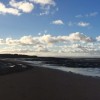
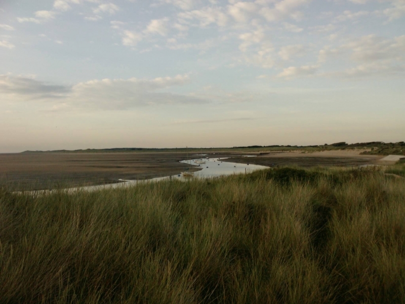
The beach is situated on the Merseyside coast, approximately 8 miles from Liverpool, and is known for its wide open sandy stretch and peaceful atmosphere. The beach is backed by an extensive system of dunes and is used by ramblers and dog walkers.
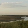
The beach and surrounding area are home to a variety of wildlife, including wading and shore birds, butterflies, and rare flora. The dunes are home to natterjack toads and sand lizards, and in spring and summer, a variety of birds make their nests in the dunes. The area of saltmarsh around the River Alt estuary is a good spot to see wildlife, and at low tide, the remnants of a submerged forest can be seen.
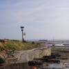
Visitors to the area should be aware of the potential dangers, including quicksands and rapidly-incoming tides with strong currents. There is a 620-acre ALTCAR military training site on the north-west side of the River Alt, where live firing takes place. There is no designated parking near the beach, although it may be possible to find a parking spot on the roads close to the beach. Access to the beach is via a short walk over the dunes.
Shops and pubs can be found in Hightown, and the beach is dog-friendly, with no restrictions on dogs. The Sefton Coastal Path passes the beach, and the area is popular with dog walkers and ramblers. The nearby Cabin Hill National Nature Reserve offers beautiful sand dunes and various habitats, making it a great spot for nature lovers and wildlife enthusiasts.
Hightown Beach is adjacent to the Sefton Coastal Footpath.
Estuary Sand Shingle
| Today | |
|---|---|
| Chance of rain | 100% |
| Max temperature | 16°C |
| feels like | 17°C |
| Wind 26mph | |
| Max UV Index |
| Tonight | |
|---|---|
| Chance of rain | 89% |
| Min temperature | 11°C |
| feels like | 11°C |
| Wind 26mph |
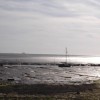
The tide at Hightown Beach is currently falling. Low tide will be at approximately 8:17 AM, and the next high tide will be at approximately 2:12 PM.
![]() Today's air pollution levels are forecast to be Low
Today's air pollution levels are forecast to be Low
Parking is limited to on-street facilities - no formal parking is available
Please keep dogs under control, keep out of Natterjack Breeding Pools and away from ground-nesting birds in spring and summer.
Hand cleansing - occasional, plus voluntary support from the local community.
No lifeguard cover at this beach
Water quality not measured here
The Dairy

From £1699.00 per week at Sykes Holiday Cottages
Ty Cerrig

From £1542.00 per week at Sykes Holiday Cottages
Jasmine Cottage

From £1520.00 per week at Sykes Holiday Cottages
Southport Coach House

From £2319.00 per week at Sykes Holiday Cottages
No 2 Emporium Apartments

From £1684.00 per week at Sykes Holiday Cottages
The Hay Barn

From £1709.00 per week at Sykes Holiday Cottages
Freshfield Squirrel Reserve (2.9 miles)
Beer Station (2.9 miles)
Asparagus Trail (3 miles)
Formby Point (3 miles)
Formby Golf Club (3 miles)
Antony Gormley's Another Place (3 miles)
Segwayz North West (3.2 miles)
Plaza Cinema (3.6 miles)
All distances are approximate
around 2 miles northwest as the seagull flies, around 5 miles by road or 4 miles on foot using coastal paths.
around 3 miles south as the seagull flies, around 6 miles by road or 3 miles on foot using coastal paths.
around 3 miles south-southeast as the seagull flies, around 6 miles by road or 3 miles on foot using coastal paths.
around 3 miles north-northwest as the seagull flies, around 6 miles by road or 4 miles on foot using coastal paths.
around 6 miles north as the seagull flies, around 8 miles by road.
around 9 miles north as the seagull flies, around 11 miles by road.
around 15 miles north as the seagull flies, around 57 miles by road or 43 miles on foot using coastal paths.
around 17 miles north as the seagull flies, around 56 miles by road or 44 miles on foot using coastal paths.
around 18 miles north as the seagull flies, around 56 miles by road.
around 20 miles north as the seagull flies, around 56 miles by road.
around 21 miles north as the seagull flies, around 57 miles by road.
around 23 miles north as the seagull flies, around 58 miles by road.
around 25 miles north as the seagull flies, around 57 miles by road.
around 30 miles north as the seagull flies, around 62 miles by road or 47 miles on foot using coastal paths.
around 6 miles south-southeast as the seagull flies, around 17 miles by road.
around 6 miles south as the seagull flies, around 17 miles by road.
around 7 miles south as the seagull flies, around 17 miles by road.
around 8 miles south-southwest as the seagull flies, around 18 miles by road.
around 9 miles south-southwest as the seagull flies, around 21 miles by road.
around 11 miles south-southwest as the seagull flies, around 23 miles by road.
Location: Hightown
Location type: Town
OS Grid: SD294034
Coordinates: 53°31'24"N 3°3'54"W
Mapcode: GBR 7W1P.6P
What 3 Words: flight.eagle.hack
Coordinates and location codes are for an approximate mid-point of the beach, and may not reflect the best access point or the most popular part of the beach.
Country: England
Local Authority: Sefton
Parish: Hightown
Nearest postcode: L38 0BU
(for sat-nav purposes only, a beach does not have a postal address!)
Important! Beach information is compiled from a variety of different sources and is correct to the best of our knowledge at the time of compilation. However, information may be incorrectly supplied by our sources or go out of date after publication. BritishBeaches.uk makes no warranty as to the accuracy of any information on this page.
(Or après-beach. Or pre-beach. Or, just because you might want stuff)
Men's Tops
Weird Fish Miles Pique Polo Shirt Mid Blue Size XL

Only £38.00 from Weird Fish